|
|
|||||||||||||||||
| Point ID: 323 | Downloads | Plots | Site Data | Code: 05BL027 |
|
|
|||||||||||||||||
| Download | |
|---|---|
| Site Descriptor Information | Site Time Series Data |
| Link to all available data | |
| View: | Time Series | All |
| Units: | m3/s |
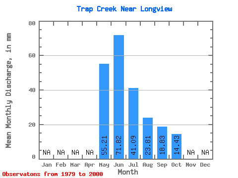
| Statistic | Jan | Feb | Mar | Apr | May | Jun | Jul | Aug | Sep | Oct | Nov | Dec | Annual |
|---|---|---|---|---|---|---|---|---|---|---|---|---|---|
| Mean | 55.20 | 71.83 | 41.08 | 23.81 | 18.83 | 14.42 | |||||||
| Standard Deviation | 33.97 | 38.28 | 31.37 | 12.18 | 11.57 | 7.69 | |||||||
| Min | 13.14 | 19.68 | 10.20 | 9.07 | 7.40 | 5.84 | |||||||
| Max | 130.97 | 164.41 | 126.47 | 59.62 | 53.35 | 33.03 | |||||||
| Coefficient of Variation | 0.61 | 0.53 | 0.76 | 0.51 | 0.61 | 0.53 |
 Return to R-Arctic Net Home Page