|
|
|||||||||||||||||
| Point ID: 323 | Downloads | Plots | Site Data | Code: 05BL027 |
|
|
|||||||||||||||||
| Download | |
|---|---|
| Site Descriptor Information | Site Time Series Data |
| Link to all available data | |
| View: | Time Series | All |
| Units: | mm |
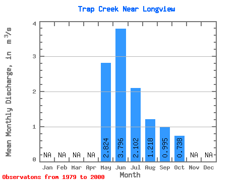
| Statistic | Jan | Feb | Mar | Apr | May | Jun | Jul | Aug | Sep | Oct | Nov | Dec | Annual |
|---|---|---|---|---|---|---|---|---|---|---|---|---|---|
| Mean | 2.82 | 3.80 | 2.10 | 1.22 | 0.99 | 0.74 | |||||||
| Standard Deviation | 1.74 | 2.02 | 1.60 | 0.62 | 0.61 | 0.39 | |||||||
| Min | 0.67 | 1.04 | 0.52 | 0.46 | 0.39 | 0.30 | |||||||
| Max | 6.70 | 8.69 | 6.47 | 3.05 | 2.82 | 1.69 | |||||||
| Coefficient of Variation | 0.61 | 0.53 | 0.76 | 0.51 | 0.61 | 0.53 |
 Return to R-Arctic Net Home Page