|
|
|||||||||||||||||
| Point ID: 3023 | Downloads | Plots | Site Data | Code: 05OF010 |
|
|
|||||||||||||||||
| Download | |
|---|---|
| Site Descriptor Information | Site Time Series Data |
| Link to all available data | |
| View: | Time Series | All |
| Units: | m3/s |
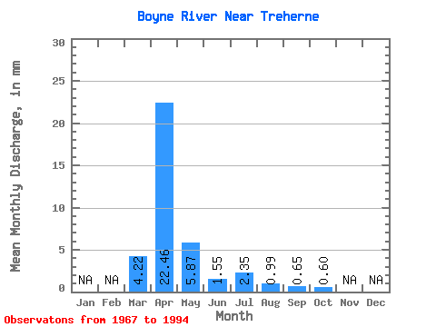
| Statistic | Jan | Feb | Mar | Apr | May | Jun | Jul | Aug | Sep | Oct | Nov | Dec | Annual |
|---|---|---|---|---|---|---|---|---|---|---|---|---|---|
| Mean | 4.22 | 22.46 | 5.88 | 1.55 | 2.35 | 0.99 | 0.66 | 0.59 | |||||
| Standard Deviation | 5.87 | 22.68 | 8.52 | 1.98 | 4.30 | 1.52 | 1.12 | 0.54 | |||||
| Min | 0.00 | 0.95 | 0.53 | 0.04 | 0.00 | 0.00 | 0.00 | 0.00 | |||||
| Max | 21.21 | 83.25 | 31.77 | 7.15 | 14.56 | 5.07 | 3.84 | 1.52 | |||||
| Coefficient of Variation | 1.39 | 1.01 | 1.45 | 1.28 | 1.83 | 1.54 | 1.71 | 0.90 |
 Return to R-Arctic Net Home Page