|
|
|||||||||||||||||
| Point ID: 3023 | Downloads | Plots | Site Data | Code: 05OF010 |
|
|
|||||||||||||||||
| Download | |
|---|---|
| Site Descriptor Information | Site Time Series Data |
| Link to all available data | |
| View: | Time Series | All |
| Units: | mm |
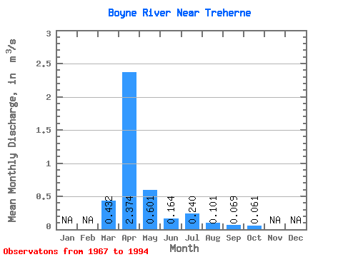
| Statistic | Jan | Feb | Mar | Apr | May | Jun | Jul | Aug | Sep | Oct | Nov | Dec | Annual |
|---|---|---|---|---|---|---|---|---|---|---|---|---|---|
| Mean | 0.43 | 2.37 | 0.60 | 0.16 | 0.24 | 0.10 | 0.07 | 0.06 | |||||
| Standard Deviation | 0.60 | 2.40 | 0.87 | 0.21 | 0.44 | 0.15 | 0.12 | 0.06 | |||||
| Min | 0.00 | 0.10 | 0.05 | 0.00 | 0.00 | 0.00 | 0.00 | 0.00 | |||||
| Max | 2.17 | 8.80 | 3.25 | 0.76 | 1.49 | 0.52 | 0.41 | 0.15 | |||||
| Coefficient of Variation | 1.39 | 1.01 | 1.45 | 1.28 | 1.83 | 1.54 | 1.71 | 0.90 |
 Return to R-Arctic Net Home Page