|
|
|||||||||||||||||
| Point ID: 2986 | Downloads | Plots | Site Data | Code: 05OC017 |
|
|
|||||||||||||||||
| Download | |
|---|---|
| Site Descriptor Information | Site Time Series Data |
| Link to all available data | |
|
|
| View: | Statistics | Time Series |
| Units: | mm |
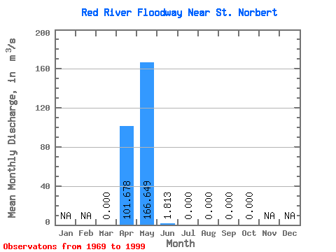
| Statistic | Jan | Feb | Mar | Apr | May | Jun | Jul | Aug | Sep | Oct | Nov | Dec | Annual |
|---|---|---|---|---|---|---|---|---|---|---|---|---|---|
| Mean | 0.00 | 101.68 | 166.65 | 1.81 | 0.00 | 0.00 | 0.00 | 0.00 | |||||
| Standard Deviation | 0.00 | 135.31 | 313.22 | 6.79 | 0.00 | 0.00 | 0.00 | 0.00 | |||||
| Min | 0.00 | 0.00 | 0.00 | 0.00 | 0.00 | 0.00 | 0.00 | 0.00 | |||||
| Max | 0.00 | 388.00 | 1140.00 | 30.60 | 0.00 | 0.00 | 0.00 | 0.00 | |||||
| Coefficient of Variation | 1.33 | 1.88 | 3.75 |
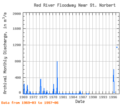
| Year | Jan | Feb | Mar | Apr | May | Jun | Jul | Aug | Sep | Oct | Nov | Dec | Annual | 1969 | 0.00 | 224.00 | 237.00 | 0.00 | 0.00 | 0.00 | 0.00 | 0.00 | 1970 | 0.00 | 150.00 | 214.00 | 0.00 | 0.00 | 0.00 | 0.00 | 0.00 | 1971 | 0.00 | 54.60 | 0.00 | 0.00 | 0.00 | 0.00 | 0.00 | 0.00 | 1972 | 0.00 | 4.15 | 0.00 | 0.00 | 0.00 | 0.00 | 0.00 | 0.00 | 1973 | 0.00 | 0.00 | 0.00 | 0.00 | 0.00 | 0.00 | 0.00 | 0.00 | 1974 | 0.00 | 341.00 | 363.00 | 0.00 | 0.00 | 0.00 | 0.00 | 0.00 | 1975 | 0.00 | 0.38 | 132.00 | 0.00 | 0.00 | 0.00 | 0.00 | 0.00 | 1976 | 0.00 | 73.50 | 0.00 | 0.00 | 0.00 | 0.00 | 0.00 | 0.00 | 1977 | 0.00 | 0.00 | 0.00 | 0.00 | 0.00 | 0.00 | 0.00 | 0.00 | 1978 | 0.00 | 231.00 | 11.90 | 0.00 | 0.00 | 0.00 | 0.00 | 0.00 | 1979 | 0.00 | 286.00 | 795.00 | 0.00 | 0.00 | 0.00 | 0.00 | 0.00 | 1980 | 0.00 | 0.00 | 0.00 | 0.00 | 0.00 | 0.00 | 0.00 | 0.00 | 1981 | 0.00 | 0.00 | 0.00 | 0.00 | 0.00 | 0.00 | 0.00 | 0.00 | 1982 | 0.00 | 2.55 | 0.00 | 0.00 | 0.00 | 0.00 | 0.00 | 0.00 | 1983 | 0.00 | 2.26 | 0.00 | 0.00 | 0.00 | 0.00 | 0.00 | 0.00 | 1984 | 0.00 | 0.00 | 0.00 | 0.00 | 0.00 | 0.00 | 0.00 | 0.00 | 1985 | 0.00 | 0.00 | 0.00 | 0.00 | 0.00 | 0.00 | 0.00 | 0.00 | 1986 | 0.00 | 68.80 | 4.72 | 0.00 | 0.00 | 0.00 | 0.00 | 0.00 | 1988 | 0.00 | 0.00 | 0.00 | 0.00 | 0.00 | 0.00 | 0.00 | 0.00 | 1996 | 309.00 | 602.00 | 30.60 | 1997 | 388.00 | 1140.00 | 7.47 | 1998 | 1999 |
|---|
 Return to R-Arctic Net Home Page