|
|
|||||||||||||||||
| Point ID: 2986 | Downloads | Plots | Site Data | Code: 05OC017 |
|
|
|||||||||||||||||
| Download | |
|---|---|
| Site Descriptor Information | Site Time Series Data |
| Link to all available data | |
| View: | Time Series | All |
| Units: | mm |
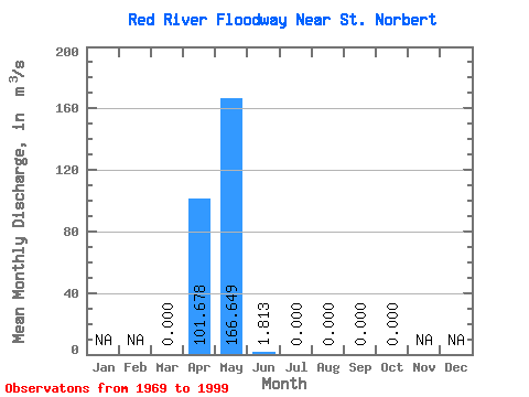
| Statistic | Jan | Feb | Mar | Apr | May | Jun | Jul | Aug | Sep | Oct | Nov | Dec | Annual |
|---|---|---|---|---|---|---|---|---|---|---|---|---|---|
| Mean | 0.00 | 101.68 | 166.65 | 1.81 | 0.00 | 0.00 | 0.00 | 0.00 | |||||
| Standard Deviation | 0.00 | 135.31 | 313.22 | 6.79 | 0.00 | 0.00 | 0.00 | 0.00 | |||||
| Min | 0.00 | 0.00 | 0.00 | 0.00 | 0.00 | 0.00 | 0.00 | 0.00 | |||||
| Max | 0.00 | 388.00 | 1140.00 | 30.60 | 0.00 | 0.00 | 0.00 | 0.00 | |||||
| Coefficient of Variation | 1.33 | 1.88 | 3.75 |
 Return to R-Arctic Net Home Page