|
|
|||||||||||||||||
| Point ID: 2962 | Downloads | Plots | Site Data | Code: 05OA012 |
|
|
|||||||||||||||||
| Download | |
|---|---|
| Site Descriptor Information | Site Time Series Data |
| Link to all available data | |
| View: | Time Series | All |
| Units: | m3/s |
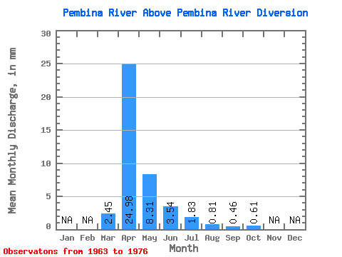
| Statistic | Jan | Feb | Mar | Apr | May | Jun | Jul | Aug | Sep | Oct | Nov | Dec | Annual |
|---|---|---|---|---|---|---|---|---|---|---|---|---|---|
| Mean | 2.45 | 24.98 | 8.30 | 3.54 | 1.83 | 0.81 | 0.46 | 0.60 | |||||
| Standard Deviation | 4.87 | 25.70 | 8.08 | 2.71 | 2.41 | 1.48 | 0.78 | 0.88 | |||||
| Min | 0.00 | 1.58 | 0.90 | 0.28 | 0.18 | 0.03 | 0.00 | 0.00 | |||||
| Max | 17.72 | 68.94 | 29.87 | 10.10 | 8.89 | 5.44 | 2.61 | 2.93 | |||||
| Coefficient of Variation | 1.99 | 1.03 | 0.97 | 0.77 | 1.31 | 1.82 | 1.70 | 1.45 |
 Return to R-Arctic Net Home Page