|
|
|||||||||||||||||
| Point ID: 2962 | Downloads | Plots | Site Data | Code: 05OA012 |
|
|
|||||||||||||||||
| Download | |
|---|---|
| Site Descriptor Information | Site Time Series Data |
| Link to all available data | |
| View: | Time Series | All |
| Units: | mm |
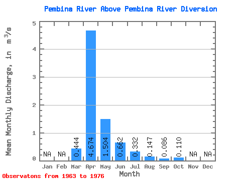
| Statistic | Jan | Feb | Mar | Apr | May | Jun | Jul | Aug | Sep | Oct | Nov | Dec | Annual |
|---|---|---|---|---|---|---|---|---|---|---|---|---|---|
| Mean | 0.44 | 4.67 | 1.50 | 0.66 | 0.33 | 0.15 | 0.09 | 0.11 | |||||
| Standard Deviation | 0.88 | 4.81 | 1.46 | 0.51 | 0.44 | 0.27 | 0.15 | 0.16 | |||||
| Min | 0.00 | 0.29 | 0.16 | 0.05 | 0.03 | 0.01 | 0.00 | 0.00 | |||||
| Max | 3.21 | 12.90 | 5.41 | 1.89 | 1.61 | 0.98 | 0.49 | 0.53 | |||||
| Coefficient of Variation | 1.99 | 1.03 | 0.97 | 0.77 | 1.31 | 1.82 | 1.70 | 1.45 |
 Return to R-Arctic Net Home Page