|
|
|||||||||||||||||
| Point ID: 2911 | Downloads | Plots | Site Data | Code: 05MH005 |
|
|
|||||||||||||||||
| Download | |
|---|---|
| Site Descriptor Information | Site Time Series Data |
| Link to all available data | |
| View: | Time Series | All |
| Units: | m3/s |
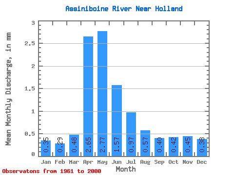
| Statistic | Jan | Feb | Mar | Apr | May | Jun | Jul | Aug | Sep | Oct | Nov | Dec | Annual |
|---|---|---|---|---|---|---|---|---|---|---|---|---|---|
| Mean | 0.35 | 0.29 | 0.48 | 2.65 | 2.77 | 1.57 | 0.97 | 0.57 | 0.40 | 0.42 | 0.45 | 0.38 | 12.24 |
| Standard Deviation | 0.14 | 0.11 | 0.30 | 2.70 | 2.91 | 1.66 | 0.86 | 0.44 | 0.29 | 0.30 | 0.22 | 0.17 | 9.06 |
| Min | 0.11 | 0.11 | 0.07 | 0.41 | 0.27 | 0.14 | 0.09 | 0.07 | 0.09 | 0.11 | 0.12 | 0.13 | 3.11 |
| Max | 0.79 | 0.58 | 1.17 | 15.48 | 10.78 | 5.88 | 3.19 | 1.67 | 1.45 | 1.83 | 1.27 | 0.98 | 38.39 |
| Coefficient of Variation | 0.41 | 0.37 | 0.63 | 1.02 | 1.05 | 1.06 | 0.89 | 0.78 | 0.73 | 0.70 | 0.49 | 0.44 | 0.74 |
 Return to R-Arctic Net Home Page