|
|
|||||||||||||||||
| Point ID: 2911 | Downloads | Plots | Site Data | Code: 05MH005 |
|
|
|||||||||||||||||
| Download | |
|---|---|
| Site Descriptor Information | Site Time Series Data |
| Link to all available data | |
| View: | Time Series | All |
| Units: | mm |
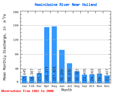
| Statistic | Jan | Feb | Mar | Apr | May | Jun | Jul | Aug | Sep | Oct | Nov | Dec | Annual |
|---|---|---|---|---|---|---|---|---|---|---|---|---|---|
| Mean | 19.64 | 18.39 | 27.30 | 155.38 | 157.43 | 92.20 | 55.07 | 32.32 | 23.41 | 24.06 | 26.16 | 21.41 | 58.96 |
| Standard Deviation | 7.97 | 6.78 | 17.24 | 158.08 | 165.26 | 97.53 | 48.71 | 25.13 | 17.09 | 16.95 | 12.86 | 9.42 | 43.63 |
| Min | 6.16 | 6.81 | 3.85 | 24.00 | 15.10 | 8.42 | 4.80 | 4.28 | 5.06 | 6.12 | 7.32 | 7.29 | 14.98 |
| Max | 44.80 | 36.10 | 66.30 | 908.00 | 612.00 | 345.00 | 181.00 | 94.80 | 85.00 | 104.00 | 74.70 | 55.50 | 184.88 |
| Coefficient of Variation | 0.41 | 0.37 | 0.63 | 1.02 | 1.05 | 1.06 | 0.89 | 0.78 | 0.73 | 0.70 | 0.49 | 0.44 | 0.74 |
 Return to R-Arctic Net Home Page