|
|
|||||||||||||||||
| Point ID: 2852 | Downloads | Plots | Site Data | Code: 05LL005 |
|
|
|||||||||||||||||
| Download | |
|---|---|
| Site Descriptor Information | Site Time Series Data |
| Link to all available data | |
| View: | Time Series | All |
| Units: | m3/s |
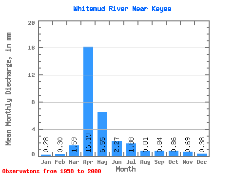
| Statistic | Jan | Feb | Mar | Apr | May | Jun | Jul | Aug | Sep | Oct | Nov | Dec | Annual |
|---|---|---|---|---|---|---|---|---|---|---|---|---|---|
| Mean | 0.28 | 0.30 | 1.59 | 16.18 | 6.55 | 2.27 | 1.88 | 0.81 | 0.84 | 0.86 | 0.69 | 0.38 | 34.45 |
| Standard Deviation | 0.17 | 0.28 | 1.95 | 15.63 | 8.67 | 2.69 | 2.90 | 1.09 | 1.51 | 0.66 | 0.43 | 0.19 | 25.40 |
| Min | 0.00 | 0.00 | 0.17 | 1.46 | 0.65 | 0.34 | 0.06 | 0.03 | 0.03 | 0.14 | 0.20 | 0.14 | 4.57 |
| Max | 0.93 | 1.66 | 7.08 | 53.10 | 36.04 | 14.57 | 13.35 | 5.34 | 8.73 | 3.16 | 1.98 | 0.88 | 96.15 |
| Coefficient of Variation | 0.61 | 0.93 | 1.23 | 0.97 | 1.32 | 1.18 | 1.54 | 1.35 | 1.81 | 0.77 | 0.62 | 0.50 | 0.74 |
 Return to R-Arctic Net Home Page