|
|
|||||||||||||||||
| Point ID: 2852 | Downloads | Plots | Site Data | Code: 05LL005 |
|
|
|||||||||||||||||
| Download | |
|---|---|
| Site Descriptor Information | Site Time Series Data |
| Link to all available data | |
| View: | Time Series | All |
| Units: | mm |
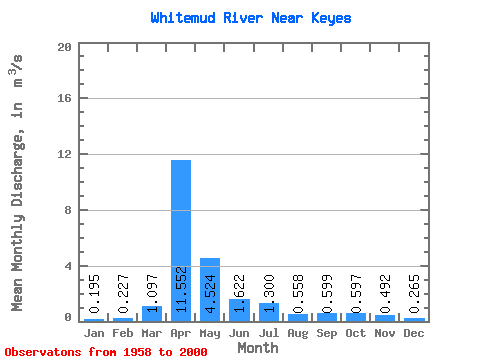
| Statistic | Jan | Feb | Mar | Apr | May | Jun | Jul | Aug | Sep | Oct | Nov | Dec | Annual |
|---|---|---|---|---|---|---|---|---|---|---|---|---|---|
| Mean | 0.20 | 0.23 | 1.10 | 11.55 | 4.52 | 1.62 | 1.30 | 0.56 | 0.60 | 0.60 | 0.49 | 0.27 | 2.02 |
| Standard Deviation | 0.12 | 0.21 | 1.35 | 11.16 | 5.99 | 1.92 | 2.00 | 0.75 | 1.08 | 0.46 | 0.31 | 0.13 | 1.49 |
| Min | 0.00 | 0.00 | 0.11 | 1.04 | 0.45 | 0.24 | 0.04 | 0.02 | 0.02 | 0.10 | 0.14 | 0.10 | 0.27 |
| Max | 0.64 | 1.26 | 4.89 | 37.90 | 24.90 | 10.40 | 9.22 | 3.69 | 6.23 | 2.18 | 1.41 | 0.61 | 5.64 |
| Coefficient of Variation | 0.61 | 0.93 | 1.23 | 0.97 | 1.32 | 1.18 | 1.54 | 1.35 | 1.81 | 0.77 | 0.62 | 0.50 | 0.74 |
 Return to R-Arctic Net Home Page