|
|
|||||||||||||||||
| Point ID: 2851 | Downloads | Plots | Site Data | Code: 05LL004 |
|
|
|||||||||||||||||
| Download | |
|---|---|
| Site Descriptor Information | Site Time Series Data |
| Link to all available data | |
| View: | Time Series | All |
| Units: | m3/s |
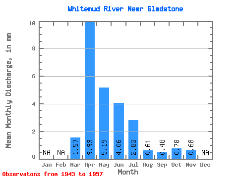
| Statistic | Jan | Feb | Mar | Apr | May | Jun | Jul | Aug | Sep | Oct | Nov | Dec | Annual |
|---|---|---|---|---|---|---|---|---|---|---|---|---|---|
| Mean | 1.57 | 9.93 | 5.19 | 4.06 | 2.83 | 0.61 | 0.48 | 0.78 | 0.68 | ||||
| Standard Deviation | 2.04 | 5.15 | 5.33 | 3.24 | 2.63 | 0.37 | 0.49 | 0.70 | 0.30 | ||||
| Min | 0.08 | 1.41 | 1.19 | 0.63 | 0.41 | 0.08 | 0.05 | 0.22 | 0.33 | ||||
| Max | 4.68 | 19.06 | 22.67 | 10.97 | 11.01 | 1.32 | 1.73 | 2.79 | 1.10 | ||||
| Coefficient of Variation | 1.30 | 0.52 | 1.03 | 0.80 | 0.93 | 0.61 | 1.01 | 0.89 | 0.44 |
 Return to R-Arctic Net Home Page