|
|
|||||||||||||||||
| Point ID: 2851 | Downloads | Plots | Site Data | Code: 05LL004 |
|
|
|||||||||||||||||
| Download | |
|---|---|
| Site Descriptor Information | Site Time Series Data |
| Link to all available data | |
| View: | Time Series | All |
| Units: | mm |
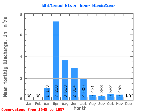
| Statistic | Jan | Feb | Mar | Apr | May | Jun | Jul | Aug | Sep | Oct | Nov | Dec | Annual |
|---|---|---|---|---|---|---|---|---|---|---|---|---|---|
| Mean | 1.11 | 7.24 | 3.66 | 2.96 | 2.00 | 0.43 | 0.35 | 0.55 | 0.49 | ||||
| Standard Deviation | 1.44 | 3.76 | 3.76 | 2.37 | 1.86 | 0.26 | 0.36 | 0.49 | 0.22 | ||||
| Min | 0.06 | 1.03 | 0.84 | 0.46 | 0.29 | 0.06 | 0.04 | 0.16 | 0.24 | ||||
| Max | 3.30 | 13.90 | 16.00 | 8.00 | 7.77 | 0.93 | 1.26 | 1.97 | 0.80 | ||||
| Coefficient of Variation | 1.30 | 0.52 | 1.03 | 0.80 | 0.93 | 0.61 | 1.01 | 0.89 | 0.44 |
 Return to R-Arctic Net Home Page