|
|
|||||||||||||||||
| Point ID: 2844 | Downloads | Plots | Site Data | Code: 05LJ045 |
|
|
|||||||||||||||||
| Download | |
|---|---|
| Site Descriptor Information | Site Time Series Data |
| Link to all available data | |
| View: | Time Series | All |
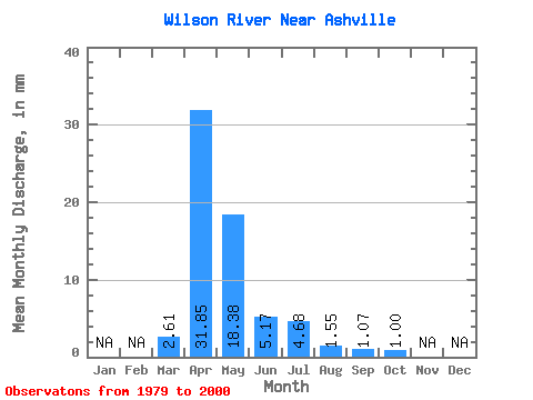
| Units: | m3/s |
| Statistic | Jan | Feb | Mar | Apr | May | Jun | Jul | Aug | Sep | Oct | Nov | Dec | Annual |
|---|---|---|---|---|---|---|---|---|---|---|---|---|---|
| Mean | 2.61 | 31.85 | 18.38 | 5.17 | 4.68 | 1.55 | 1.07 | 1.00 | |||||
| Standard Deviation | 5.19 | 28.15 | 24.80 | 12.09 | 8.51 | 2.79 | 2.54 | 2.19 | |||||
| Min | 0.00 | 2.12 | 0.10 | 0.01 | 0.00 | 0.00 | 0.00 | 0.00 | |||||
| Max | 19.17 | 101.12 | 96.47 | 58.50 | 27.50 | 10.45 | 11.51 | 9.93 | |||||
| Coefficient of Variation | 1.99 | 0.88 | 1.35 | 2.34 | 1.82 | 1.80 | 2.37 | 2.20 |
 Return to R-Arctic Net Home Page