|
|
|||||||||||||||||
| Point ID: 2844 | Downloads | Plots | Site Data | Code: 05LJ045 |
|
|
|||||||||||||||||
| Download | |
|---|---|
| Site Descriptor Information | Site Time Series Data |
| Link to all available data | |
| View: | Time Series | All |
| Units: | mm |
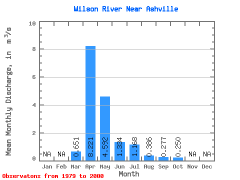
| Statistic | Jan | Feb | Mar | Apr | May | Jun | Jul | Aug | Sep | Oct | Nov | Dec | Annual |
|---|---|---|---|---|---|---|---|---|---|---|---|---|---|
| Mean | 0.65 | 8.22 | 4.59 | 1.33 | 1.17 | 0.39 | 0.28 | 0.25 | |||||
| Standard Deviation | 1.30 | 7.27 | 6.20 | 3.12 | 2.12 | 0.70 | 0.66 | 0.55 | |||||
| Min | 0.00 | 0.55 | 0.02 | 0.00 | 0.00 | 0.00 | 0.00 | 0.00 | |||||
| Max | 4.79 | 26.10 | 24.10 | 15.10 | 6.87 | 2.61 | 2.97 | 2.48 | |||||
| Coefficient of Variation | 1.99 | 0.88 | 1.35 | 2.34 | 1.82 | 1.80 | 2.37 | 2.20 |
 Return to R-Arctic Net Home Page