|
|
|||||||||||||||||
| Point ID: 2837 | Downloads | Plots | Site Data | Code: 05LJ029 |
|
|
|||||||||||||||||
| Download | |
|---|---|
| Site Descriptor Information | Site Time Series Data |
| Link to all available data | |
|
|
| View: | Statistics | Time Series |
| Units: | mm |
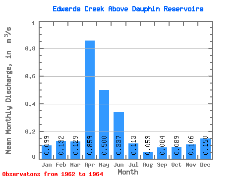
| Statistic | Jan | Feb | Mar | Apr | May | Jun | Jul | Aug | Sep | Oct | Nov | Dec | Annual |
|---|---|---|---|---|---|---|---|---|---|---|---|---|---|
| Mean | 0.10 | 0.13 | 0.13 | 0.86 | 0.50 | 0.34 | 0.11 | 0.05 | 0.08 | 0.09 | 0.11 | 0.15 | 0.26 |
| Standard Deviation | 0.04 | 0.02 | 0.00 | 0.33 | 0.07 | 0.36 | 0.00 | ||||||
| Min | 0.07 | 0.12 | 0.13 | 0.63 | 0.45 | 0.08 | 0.11 | 0.05 | 0.08 | 0.09 | 0.11 | 0.15 | 0.26 |
| Max | 0.13 | 0.15 | 0.13 | 1.09 | 0.55 | 0.59 | 0.11 | 0.05 | 0.08 | 0.09 | 0.11 | 0.15 | 0.26 |
| Coefficient of Variation | 0.41 | 0.15 | 0.01 | 0.38 | 0.15 | 1.07 | 0.01 |
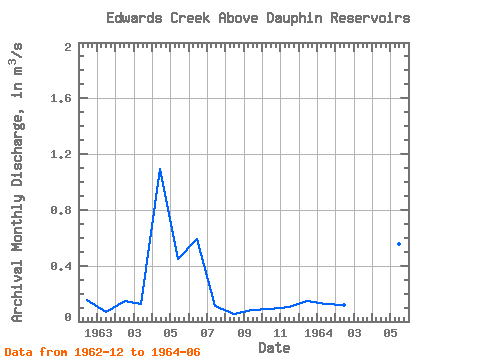
| Year | Jan | Feb | Mar | Apr | May | Jun | Jul | Aug | Sep | Oct | Nov | Dec | Annual | 1962 | 0.15 | 1963 | 0.07 | 0.15 | 0.13 | 1.09 | 0.45 | 0.59 | 0.11 | 0.05 | 0.08 | 0.09 | 0.11 | 0.15 | 0.26 | 1964 | 0.13 | 0.12 | 0.13 | 0.63 | 0.55 | 0.08 |
|---|
 Return to R-Arctic Net Home Page