|
|
|||||||||||||||||
| Point ID: 2837 | Downloads | Plots | Site Data | Code: 05LJ029 |
|
|
|||||||||||||||||
| Download | |
|---|---|
| Site Descriptor Information | Site Time Series Data |
| Link to all available data | |
|
|
| View: | Statistics | Time Series |
| Units: | m3/s |
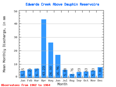
| Statistic | Jan | Feb | Mar | Apr | May | Jun | Jul | Aug | Sep | Oct | Nov | Dec | Annual |
|---|---|---|---|---|---|---|---|---|---|---|---|---|---|
| Mean | 5.12 | 6.25 | 6.73 | 43.23 | 26.00 | 16.99 | 5.88 | 2.76 | 4.23 | 4.63 | 5.33 | 7.83 | 156.88 |
| Standard Deviation | 2.10 | 0.94 | 0.04 | 16.44 | 3.82 | 18.26 | 0.04 | ||||||
| Min | 3.64 | 5.59 | 6.71 | 31.61 | 23.30 | 4.08 | 5.88 | 2.76 | 4.23 | 4.63 | 5.33 | 7.80 | 156.88 |
| Max | 6.60 | 6.92 | 6.76 | 54.86 | 28.70 | 29.90 | 5.88 | 2.76 | 4.23 | 4.63 | 5.33 | 7.85 | 156.88 |
| Coefficient of Variation | 0.41 | 0.15 | 0.01 | 0.38 | 0.15 | 1.07 | 0.01 |
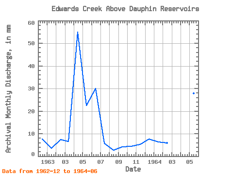
| Year | Jan | Feb | Mar | Apr | May | Jun | Jul | Aug | Sep | Oct | Nov | Dec | Annual | 1962 | 7.85 | 1963 | 3.64 | 6.92 | 6.71 | 54.86 | 23.30 | 29.90 | 5.88 | 2.76 | 4.23 | 4.63 | 5.33 | 7.80 | 156.88 | 1964 | 6.60 | 5.59 | 6.76 | 31.61 | 28.70 | 4.08 |
|---|
 Return to R-Arctic Net Home Page