|
|
|||||||||||||||||
| Point ID: 2823 | Downloads | Plots | Site Data | Code: 05LJ013 |
|
|
|||||||||||||||||
| Download | |
|---|---|
| Site Descriptor Information | Site Time Series Data |
| Link to all available data | |
|
|
| View: | Statistics | Time Series |
| Units: | mm |
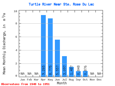
| Statistic | Jan | Feb | Mar | Apr | May | Jun | Jul | Aug | Sep | Oct | Nov | Dec | Annual |
|---|---|---|---|---|---|---|---|---|---|---|---|---|---|
| Mean | 9.27 | 8.78 | 5.56 | 3.10 | 1.49 | 0.85 | 0.88 | ||||||
| Standard Deviation | 3.58 | 7.26 | 5.24 | 2.69 | 1.50 | 0.64 | 0.54 | ||||||
| Min | 6.73 | 1.87 | 2.40 | 1.14 | 0.39 | 0.29 | 0.26 | ||||||
| Max | 11.80 | 18.80 | 11.60 | 6.17 | 3.19 | 1.55 | 1.25 | ||||||
| Coefficient of Variation | 0.39 | 0.83 | 0.94 | 0.87 | 1.01 | 0.76 | 0.62 |
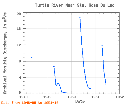
| Year | Jan | Feb | Mar | Apr | May | Jun | Jul | Aug | Sep | Oct | Nov | Dec | Annual | 1948 | 8.82 | 1949 | 6.73 | 1.87 | 2.67 | 1.98 | 0.39 | 0.29 | 0.26 | 1950 | 18.80 | 11.60 | 6.17 | 3.19 | 1.55 | 1.25 | 1951 | 11.80 | 5.61 | 2.40 | 1.14 | 0.88 | 0.71 | 1.12 |
|---|
 Return to R-Arctic Net Home Page