|
|
|||||||||||||||||
| Point ID: 2823 | Downloads | Plots | Site Data | Code: 05LJ013 |
|
|
|||||||||||||||||
| Download | |
|---|---|
| Site Descriptor Information | Site Time Series Data |
| Link to all available data | |
|
|
| View: | Statistics | Time Series |
| Units: | m3/s |
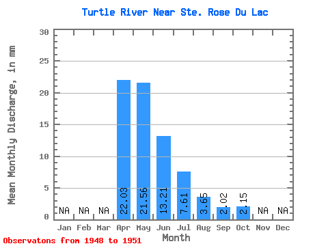
| Statistic | Jan | Feb | Mar | Apr | May | Jun | Jul | Aug | Sep | Oct | Nov | Dec | Annual |
|---|---|---|---|---|---|---|---|---|---|---|---|---|---|
| Mean | 22.03 | 21.56 | 13.21 | 7.61 | 3.65 | 2.02 | 2.15 | ||||||
| Standard Deviation | 8.53 | 17.84 | 12.45 | 6.62 | 3.67 | 1.53 | 1.33 | ||||||
| Min | 16.00 | 4.59 | 5.71 | 2.80 | 0.95 | 0.69 | 0.63 | ||||||
| Max | 28.06 | 46.19 | 27.59 | 15.16 | 7.84 | 3.69 | 3.07 | ||||||
| Coefficient of Variation | 0.39 | 0.83 | 0.94 | 0.87 | 1.01 | 0.76 | 0.62 |
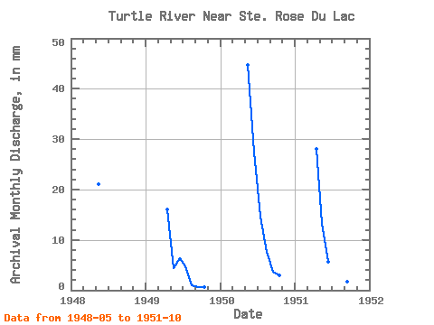
| Year | Jan | Feb | Mar | Apr | May | Jun | Jul | Aug | Sep | Oct | Nov | Dec | Annual | 1948 | 21.67 | 1949 | 16.00 | 4.59 | 6.35 | 4.87 | 0.95 | 0.69 | 0.63 | 1950 | 46.19 | 27.59 | 15.16 | 7.84 | 3.69 | 3.07 | 1951 | 28.06 | 13.78 | 5.71 | 2.80 | 2.17 | 1.68 | 2.75 |
|---|
 Return to R-Arctic Net Home Page