|
|
|||||||||||||||||
| Point ID: 2778 | Downloads | Plots | Site Data | Code: 10CD002 |
|
|
|||||||||||||||||
| Download | |
|---|---|
| Site Descriptor Information | Site Time Series Data |
| Link to all available data | |
|
|
| View: | Statistics | Time Series |
| Units: | mm |
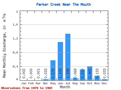
| Statistic | Jan | Feb | Mar | Apr | May | Jun | Jul | Aug | Sep | Oct | Nov | Dec | Annual |
|---|---|---|---|---|---|---|---|---|---|---|---|---|---|
| Mean | 0.00 | 0.00 | 0.00 | 0.03 | 0.57 | 1.10 | 1.34 | 0.07 | 0.31 | 0.40 | 0.13 | 0.03 | 0.43 |
| Standard Deviation | 0.00 | 0.00 | 0.00 | 0.05 | 0.60 | 0.00 | 0.01 | 0.42 | 0.24 | 0.06 | |||
| Min | 0.00 | 0.00 | 0.00 | 0.00 | 0.57 | 1.10 | 0.92 | 0.07 | 0.30 | 0.10 | 0.00 | 0.00 | 0.43 |
| Max | 0.01 | 0.00 | 0.00 | 0.09 | 0.57 | 1.10 | 1.76 | 0.07 | 0.32 | 0.70 | 0.49 | 0.12 | 0.43 |
| Coefficient of Variation | 1.73 | 1.73 | 1.40 | 0.45 | 0.04 | 0.04 | 1.05 | 1.80 | 1.79 |
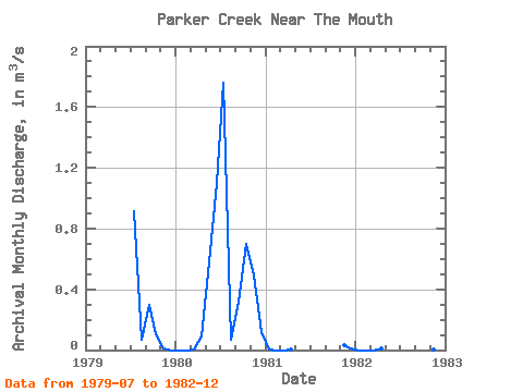
| Year | Jan | Feb | Mar | Apr | May | Jun | Jul | Aug | Sep | Oct | Nov | Dec | Annual | 1979 | 0.92 | 0.07 | 0.30 | 0.10 | 0.01 | 0.00 | 1980 | 0.00 | 0.00 | 0.00 | 0.09 | 0.57 | 1.10 | 1.76 | 0.07 | 0.32 | 0.70 | 0.49 | 0.12 | 0.43 | 1981 | 0.01 | 0.00 | 0.00 | 0.00 | 0.03 | 0.01 | 1982 | 0.00 | 0.00 | 0.00 | 0.01 | 0.00 | 0.00 |
|---|
 Return to R-Arctic Net Home Page