|
|
|||||||||||||||||
| Point ID: 2778 | Downloads | Plots | Site Data | Code: 10CD002 |
|
|
|||||||||||||||||
| Download | |
|---|---|
| Site Descriptor Information | Site Time Series Data |
| Link to all available data | |
|
|
| View: | Statistics | Time Series |
| Units: | m3/s |
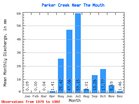
| Statistic | Jan | Feb | Mar | Apr | May | Jun | Jul | Aug | Sep | Oct | Nov | Dec | Annual |
|---|---|---|---|---|---|---|---|---|---|---|---|---|---|
| Mean | 0.09 | 0.00 | 0.03 | 1.43 | 25.41 | 47.06 | 59.14 | 3.01 | 13.24 | 17.77 | 5.71 | 1.46 | 226.71 |
| Standard Deviation | 0.15 | 0.00 | 0.05 | 1.99 | 26.38 | 0.12 | 0.57 | 18.63 | 10.27 | 2.60 | |||
| Min | 0.00 | 0.00 | 0.00 | 0.17 | 25.41 | 47.06 | 40.49 | 2.92 | 12.83 | 4.60 | 0.04 | 0.00 | 226.71 |
| Max | 0.27 | 0.00 | 0.09 | 3.72 | 25.41 | 47.06 | 77.79 | 3.09 | 13.65 | 30.94 | 21.09 | 5.35 | 226.71 |
| Coefficient of Variation | 1.73 | 1.73 | 1.40 | 0.45 | 0.04 | 0.04 | 1.05 | 1.80 | 1.79 |
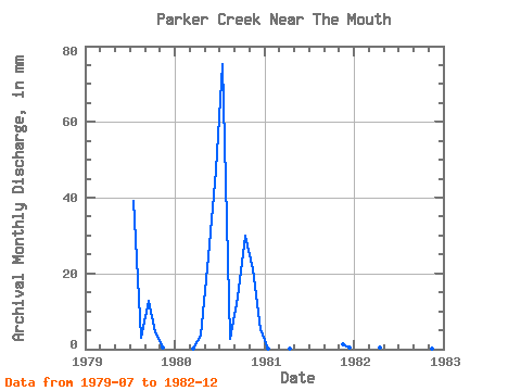
| Year | Jan | Feb | Mar | Apr | May | Jun | Jul | Aug | Sep | Oct | Nov | Dec | Annual | 1979 | 40.49 | 3.09 | 12.83 | 4.60 | 0.43 | 0.00 | 1980 | 0.00 | 0.00 | 0.09 | 3.72 | 25.41 | 47.06 | 77.79 | 2.92 | 13.65 | 30.94 | 21.09 | 5.35 | 226.71 | 1981 | 0.27 | 0.00 | 0.00 | 0.17 | 1.28 | 0.49 | 1982 | 0.00 | 0.00 | 0.00 | 0.39 | 0.04 | 0.00 |
|---|
 Return to R-Arctic Net Home Page