|
|
|||||||||||||||||
| Point ID: 2768 | Downloads | Plots | Site Data | Code: 10BE009 |
|
|
|||||||||||||||||
| Download | |
|---|---|
| Site Descriptor Information | Site Time Series Data |
| Link to all available data | |
| View: | Time Series | All |
| Units: | m3/s |
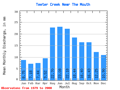
| Statistic | Jan | Feb | Mar | Apr | May | Jun | Jul | Aug | Sep | Oct | Nov | Dec | Annual |
|---|---|---|---|---|---|---|---|---|---|---|---|---|---|
| Mean | 8.75 | 7.24 | 7.44 | 9.52 | 22.69 | 23.08 | 22.18 | 18.44 | 16.41 | 16.42 | 12.25 | 10.90 | 174.51 |
| Standard Deviation | 2.81 | 2.09 | 1.94 | 2.23 | 8.33 | 10.37 | 13.68 | 7.24 | 5.16 | 6.29 | 3.90 | 3.30 | 49.90 |
| Min | 2.98 | 2.61 | 2.79 | 5.37 | 10.45 | 9.12 | 8.99 | 9.73 | 8.81 | 8.69 | 7.00 | 5.37 | 108.24 |
| Max | 14.09 | 10.96 | 10.47 | 14.62 | 35.66 | 49.14 | 62.44 | 39.47 | 25.92 | 31.86 | 20.76 | 17.39 | 292.08 |
| Coefficient of Variation | 0.32 | 0.29 | 0.26 | 0.23 | 0.37 | 0.45 | 0.62 | 0.39 | 0.32 | 0.38 | 0.32 | 0.30 | 0.29 |
 Return to R-Arctic Net Home Page