|
|
|||||||||||||||||
| Point ID: 2768 | Downloads | Plots | Site Data | Code: 10BE009 |
|
|
|||||||||||||||||
| Download | |
|---|---|
| Site Descriptor Information | Site Time Series Data |
| Link to all available data | |
| View: | Time Series | All |
| Units: | mm |
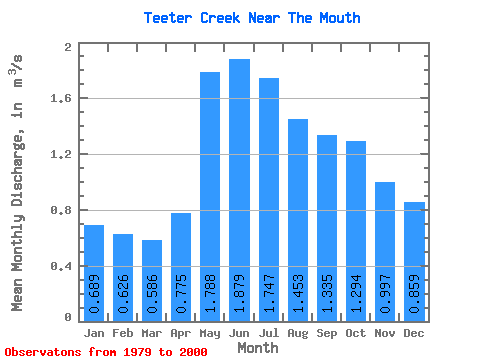
| Statistic | Jan | Feb | Mar | Apr | May | Jun | Jul | Aug | Sep | Oct | Nov | Dec | Annual |
|---|---|---|---|---|---|---|---|---|---|---|---|---|---|
| Mean | 0.69 | 0.63 | 0.59 | 0.78 | 1.79 | 1.88 | 1.75 | 1.45 | 1.33 | 1.29 | 1.00 | 0.86 | 1.17 |
| Standard Deviation | 0.22 | 0.18 | 0.15 | 0.18 | 0.66 | 0.84 | 1.08 | 0.57 | 0.42 | 0.49 | 0.32 | 0.26 | 0.33 |
| Min | 0.23 | 0.23 | 0.22 | 0.44 | 0.82 | 0.74 | 0.71 | 0.77 | 0.72 | 0.69 | 0.57 | 0.42 | 0.72 |
| Max | 1.11 | 0.95 | 0.82 | 1.19 | 2.81 | 4.00 | 4.92 | 3.11 | 2.11 | 2.51 | 1.69 | 1.37 | 1.95 |
| Coefficient of Variation | 0.32 | 0.29 | 0.26 | 0.23 | 0.37 | 0.45 | 0.62 | 0.39 | 0.32 | 0.38 | 0.32 | 0.30 | 0.29 |
 Return to R-Arctic Net Home Page