|
|
|||||||||||||||||
| Point ID: 255 | Downloads | Plots | Site Data | Code: 05BE999 |
|
|
|||||||||||||||||
| Download | |
|---|---|
| Site Descriptor Information | Site Time Series Data |
| Link to all available data | |
|
|
| View: | Statistics | Time Series |
| Units: | mm |
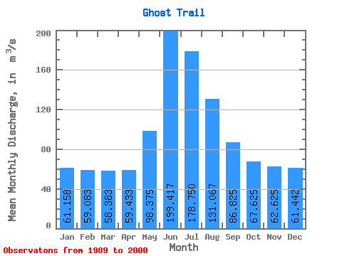
| Statistic | Jan | Feb | Mar | Apr | May | Jun | Jul | Aug | Sep | Oct | Nov | Dec | Annual |
|---|---|---|---|---|---|---|---|---|---|---|---|---|---|
| Mean | 61.16 | 59.08 | 58.38 | 59.43 | 98.38 | 199.42 | 178.75 | 131.07 | 86.83 | 67.62 | 62.62 | 61.44 | 93.68 |
| Standard Deviation | 5.69 | 4.99 | 4.16 | 5.99 | 19.71 | 63.63 | 46.35 | 26.30 | 17.13 | 9.59 | 8.00 | 7.24 | 11.06 |
| Min | 54.50 | 52.10 | 52.10 | 50.30 | 74.20 | 119.00 | 129.00 | 96.80 | 60.40 | 51.90 | 48.90 | 51.60 | 79.82 |
| Max | 69.40 | 69.30 | 67.40 | 70.50 | 128.00 | 333.00 | 272.00 | 181.00 | 116.00 | 78.80 | 72.60 | 74.10 | 113.22 |
| Coefficient of Variation | 0.09 | 0.08 | 0.07 | 0.10 | 0.20 | 0.32 | 0.26 | 0.20 | 0.20 | 0.14 | 0.13 | 0.12 | 0.12 |
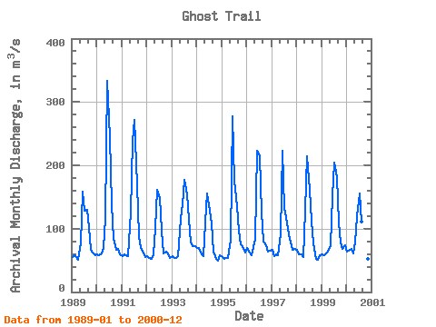
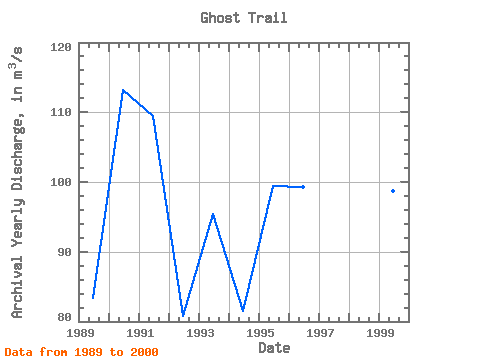
| Year | Jan | Feb | Mar | Apr | May | Jun | Jul | Aug | Sep | Oct | Nov | Dec | Annual | 1989 | 54.50 | 57.70 | 55.80 | 50.30 | 76.20 | 158.00 | 129.00 | 130.00 | 101.00 | 66.40 | 62.80 | 58.70 | 83.37 | 1990 | 59.00 | 57.40 | 61.30 | 69.10 | 116.00 | 333.00 | 244.00 | 139.00 | 84.10 | 67.20 | 68.80 | 59.70 | 113.22 | 1991 | 56.70 | 58.90 | 57.80 | 56.90 | 125.00 | 239.00 | 272.00 | 170.00 | 88.10 | 70.10 | 64.30 | 54.80 | 109.47 | 1992 | 56.30 | 54.40 | 52.10 | 59.60 | 101.00 | 161.00 | 149.00 | 96.80 | 60.40 | 63.70 | 60.70 | 53.60 | 80.72 | 1993 | 56.20 | 54.40 | 54.30 | 56.40 | 115.00 | 139.00 | 177.00 | 154.00 | 116.00 | 78.00 | 72.20 | 72.10 | 95.38 | 1994 | 69.40 | 69.30 | 60.00 | 56.20 | 109.00 | 155.00 | 129.00 | 108.00 | 64.10 | 51.90 | 48.90 | 57.80 | 81.55 | 1995 | 55.40 | 52.10 | 53.40 | 54.10 | 83.10 | 278.00 | 175.00 | 136.00 | 96.30 | 74.60 | 72.60 | 62.70 | 99.44 | 1996 | 69.40 | 64.40 | 58.30 | 70.50 | 83.20 | 223.00 | 214.00 | 126.00 | 80.00 | 73.20 | 63.50 | 65.10 | 99.22 | 1997 | 66.20 | 57.30 | 60.10 | 58.60 | 91.20 | 223.00 | 133.00 | 109.00 | 90.90 | 78.80 | 66.00 | 68.70 | 91.90 | 1998 | 67.00 | 59.20 | 59.30 | 55.90 | 128.00 | 214.00 | 162.00 | 112.00 | 77.10 | 52.40 | 51.60 | 58.40 | 91.41 | 1999 | 59.70 | 58.50 | 60.80 | 64.40 | 74.20 | 151.00 | 205.00 | 181.00 | 110.00 | 77.50 | 68.20 | 74.10 | 98.70 | 2000 | 64.10 | 65.40 | 67.40 | 61.20 | 78.60 | 119.00 | 156.00 | 111.00 | 73.90 | 57.70 | 51.90 | 51.60 | 79.82 |
|---|
 Return to R-Arctic Net Home Page