|
|
|||||||||||||||||
| Point ID: 255 | Downloads | Plots | Site Data | Code: 05BE999 |
|
|
|||||||||||||||||
| Download | |
|---|---|
| Site Descriptor Information | Site Time Series Data |
| Link to all available data | |
| View: | Time Series | All |
| Units: | mm |
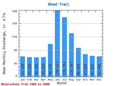
| Statistic | Jan | Feb | Mar | Apr | May | Jun | Jul | Aug | Sep | Oct | Nov | Dec | Annual |
|---|---|---|---|---|---|---|---|---|---|---|---|---|---|
| Mean | 61.16 | 59.08 | 58.38 | 59.43 | 98.38 | 199.42 | 178.75 | 131.07 | 86.83 | 67.62 | 62.62 | 61.44 | 93.68 |
| Standard Deviation | 5.69 | 4.99 | 4.16 | 5.99 | 19.71 | 63.63 | 46.35 | 26.30 | 17.13 | 9.59 | 8.00 | 7.24 | 11.06 |
| Min | 54.50 | 52.10 | 52.10 | 50.30 | 74.20 | 119.00 | 129.00 | 96.80 | 60.40 | 51.90 | 48.90 | 51.60 | 79.82 |
| Max | 69.40 | 69.30 | 67.40 | 70.50 | 128.00 | 333.00 | 272.00 | 181.00 | 116.00 | 78.80 | 72.60 | 74.10 | 113.22 |
| Coefficient of Variation | 0.09 | 0.08 | 0.07 | 0.10 | 0.20 | 0.32 | 0.26 | 0.20 | 0.20 | 0.14 | 0.13 | 0.12 | 0.12 |
 Return to R-Arctic Net Home Page