|
|
|||||||||||||||||
| Point ID: 194 | Downloads | Plots | Site Data | Code: 05AH003 |
|
|
|||||||||||||||||
| Download | |
|---|---|
| Site Descriptor Information | Site Time Series Data |
| Link to all available data | |
| View: | Time Series | All |
| Units: | m3/s |
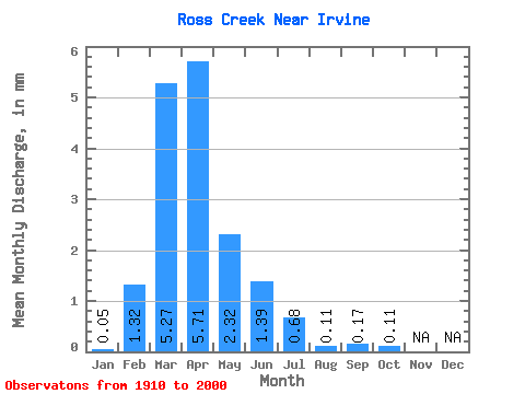
| Statistic | Jan | Feb | Mar | Apr | May | Jun | Jul | Aug | Sep | Oct | Nov | Dec | Annual |
|---|---|---|---|---|---|---|---|---|---|---|---|---|---|
| Mean | 0.05 | 1.31 | 5.16 | 5.59 | 2.27 | 1.36 | 0.67 | 0.11 | 0.17 | 0.11 | |||
| Standard Deviation | 2.59 | 5.97 | 8.50 | 4.80 | 3.36 | 1.94 | 0.40 | 0.66 | 0.36 | ||||
| Min | 0.05 | 0.00 | 0.00 | 0.00 | 0.00 | 0.00 | 0.00 | 0.00 | 0.00 | 0.00 | |||
| Max | 0.05 | 10.14 | 27.32 | 41.26 | 27.61 | 20.59 | 11.05 | 2.55 | 4.25 | 2.40 | |||
| Coefficient of Variation | 1.98 | 1.16 | 1.52 | 2.12 | 2.47 | 2.90 | 3.59 | 3.96 | 3.37 |
 Return to R-Arctic Net Home Page