|
|
|||||||||||||||||
| Point ID: 194 | Downloads | Plots | Site Data | Code: 05AH003 |
|
|
|||||||||||||||||
| Download | |
|---|---|
| Site Descriptor Information | Site Time Series Data |
| Link to all available data | |
| View: | Time Series | All |
| Units: | mm |
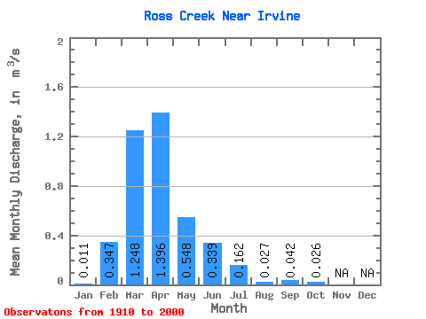
| Statistic | Jan | Feb | Mar | Apr | May | Jun | Jul | Aug | Sep | Oct | Nov | Dec | Annual |
|---|---|---|---|---|---|---|---|---|---|---|---|---|---|
| Mean | 0.01 | 0.35 | 1.25 | 1.40 | 0.55 | 0.34 | 0.16 | 0.03 | 0.04 | 0.03 | |||
| Standard Deviation | 0.69 | 1.44 | 2.12 | 1.16 | 0.84 | 0.47 | 0.10 | 0.17 | 0.09 | ||||
| Min | 0.01 | 0.00 | 0.00 | 0.00 | 0.00 | 0.00 | 0.00 | 0.00 | 0.00 | 0.00 | |||
| Max | 0.01 | 2.69 | 6.60 | 10.30 | 6.67 | 5.14 | 2.67 | 0.62 | 1.06 | 0.58 | |||
| Coefficient of Variation | 1.98 | 1.16 | 1.52 | 2.12 | 2.47 | 2.90 | 3.59 | 3.96 | 3.37 |
 Return to R-Arctic Net Home Page