|
|
|||||||||||||||||
| Point ID: 16 | Downloads | Plots | Site Data | Code: 05AA021 |
|
|
|||||||||||||||||
| Download | |
|---|---|
| Site Descriptor Information | Site Time Series Data |
| Link to all available data | |
|
|
| View: | Statistics | Time Series |
| Units: | mm |
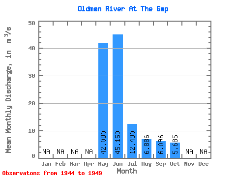
| Statistic | Jan | Feb | Mar | Apr | May | Jun | Jul | Aug | Sep | Oct | Nov | Dec | Annual |
|---|---|---|---|---|---|---|---|---|---|---|---|---|---|
| Mean | 42.08 | 45.15 | 12.49 | 6.89 | 6.10 | 5.69 | |||||||
| Standard Deviation | 20.26 | 27.28 | 4.46 | 2.94 | 2.30 | 2.85 | |||||||
| Min | 25.60 | 12.70 | 7.13 | 3.66 | 3.12 | 2.64 | |||||||
| Max | 73.90 | 79.60 | 17.00 | 10.30 | 8.46 | 9.47 | |||||||
| Coefficient of Variation | 0.48 | 0.60 | 0.36 | 0.43 | 0.38 | 0.50 |
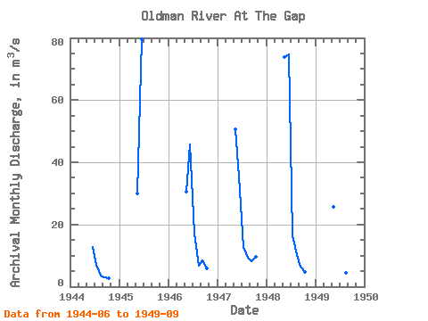
| Year | Jan | Feb | Mar | Apr | May | Jun | Jul | Aug | Sep | Oct | Nov | Dec | Annual | 1944 | 12.70 | 7.13 | 3.66 | 3.12 | 2.64 | 1945 | 29.90 | 79.60 | 1946 | 30.40 | 45.80 | 17.00 | 6.66 | 8.46 | 5.83 | 1947 | 50.60 | 35.30 | 12.90 | 9.39 | 8.03 | 9.47 | 1948 | 73.90 | 74.80 | 16.60 | 10.30 | 6.45 | 4.80 | 1949 | 25.60 | 22.70 | 8.82 | 4.42 | 4.42 |
|---|
 Return to R-Arctic Net Home Page