|
|
|||||||||||||||||
| Point ID: 16 | Downloads | Plots | Site Data | Code: 05AA021 |
|
|
|||||||||||||||||
| Download | |
|---|---|
| Site Descriptor Information | Site Time Series Data |
| Link to all available data | |

|
|
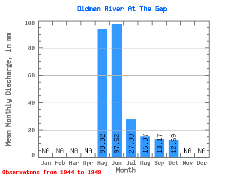
| View: | Statistics | Time Series |
| Units: | m3/s |
| Statistic | Jan | Feb | Mar | Apr | May | Jun | Jul | Aug | Sep | Oct | Nov | Dec | Annual |
|---|---|---|---|---|---|---|---|---|---|---|---|---|---|
| Mean | 93.91 | 97.52 | 27.87 | 15.37 | 13.17 | 12.69 | |||||||
| Standard Deviation | 45.21 | 58.92 | 9.96 | 6.55 | 4.96 | 6.37 | |||||||
| Min | 57.13 | 27.43 | 15.91 | 8.17 | 6.74 | 5.89 | |||||||
| Max | 164.92 | 171.94 | 37.94 | 22.99 | 18.27 | 21.13 | |||||||
| Coefficient of Variation | 0.48 | 0.60 | 0.36 | 0.43 | 0.38 | 0.50 |
| Year | Jan | Feb | Mar | Apr | May | Jun | Jul | Aug | Sep | Oct | Nov | Dec | Annual | 1944 | 27.43 | 15.91 | 8.17 | 6.74 | 5.89 | 1945 | 66.73 | 171.94 | 1946 | 67.84 | 98.93 | 37.94 | 14.86 | 18.27 | 13.01 | 1947 | 112.92 | 76.25 | 28.79 | 20.95 | 17.34 | 21.13 | 1948 | 164.92 | 161.57 | 37.05 | 22.99 | 13.93 | 10.71 | 1949 | 57.13 | 49.03 | 19.68 | 9.86 | 9.55 |
|---|
 Return to R-Arctic Net Home Page