|
|
|||||||||||||||||
| Point ID: 129 | Downloads | Plots | Site Data | Code: 05AE010 |
|
|
|||||||||||||||||
| Download | |
|---|---|
| Site Descriptor Information | Site Time Series Data |
| Link to all available data | |
|
|
| View: | Statistics | Time Series |
| Units: | mm |
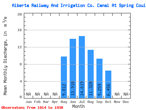
| Statistic | Jan | Feb | Mar | Apr | May | Jun | Jul | Aug | Sep | Oct | Nov | Dec | Annual |
|---|---|---|---|---|---|---|---|---|---|---|---|---|---|
| Mean | 9.81 | 13.92 | 14.62 | 11.33 | 9.26 | 6.46 | |||||||
| Standard Deviation | 2.62 | 5.61 | 5.80 | 3.17 | 2.70 | 4.55 | |||||||
| Min | 5.22 | 5.20 | 2.89 | 5.42 | 4.91 | 1.12 | |||||||
| Max | 14.20 | 22.10 | 23.40 | 15.90 | 13.60 | 12.80 | |||||||
| Coefficient of Variation | 0.27 | 0.40 | 0.40 | 0.28 | 0.29 | 0.70 |
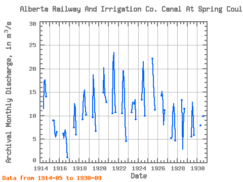
| Year | Jan | Feb | Mar | Apr | May | Jun | Jul | Aug | Sep | Oct | Nov | Dec | Annual | 1914 | 11.40 | 17.10 | 17.60 | 14.00 | 1915 | 8.97 | 8.93 | 6.42 | 5.42 | 6.47 | 1916 | 6.16 | 5.20 | 6.52 | 6.91 | 4.91 | 1.12 | 1917 | 7.46 | 12.50 | 11.60 | 5.95 | 1918 | 9.21 | 14.30 | 15.40 | 12.40 | 10.20 | 1919 | 9.59 | 18.70 | 15.00 | 9.16 | 6.77 | 1920 | 14.90 | 20.20 | 14.40 | 13.60 | 12.80 | 1921 | 10.50 | 20.90 | 23.40 | 15.90 | 10.70 | 1922 | 10.50 | 19.50 | 19.50 | 14.60 | 8.49 | 4.54 | 1923 | 10.70 | 12.80 | 12.60 | 12.40 | 13.40 | 9.14 | 1924 | 13.40 | 16.00 | 21.40 | 14.00 | 9.94 | 1925 | 22.10 | 19.80 | 14.70 | 11.20 | 1926 | 14.20 | 15.10 | 12.90 | 7.98 | 11.10 | 1927 | 5.22 | 5.42 | 10.30 | 12.50 | 9.78 | 4.68 | 1928 | 13.30 | 2.89 | 7.78 | 11.50 | 1929 | 5.49 | 12.90 | 9.02 | 5.81 | 1930 | 7.90 | 19.40 | 19.20 | 9.81 | 8.33 |
|---|
 Return to R-Arctic Net Home Page