|
|
|||||||||||||||||
| Point ID: 129 | Downloads | Plots | Site Data | Code: 05AE010 |
|
|
|||||||||||||||||
| Download | |
|---|---|
| Site Descriptor Information | Site Time Series Data |
| Link to all available data | |
| View: | Time Series | All |
| Units: | mm |
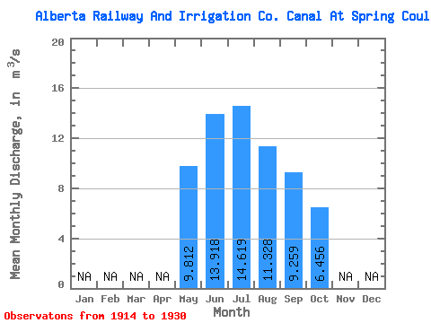
| Statistic | Jan | Feb | Mar | Apr | May | Jun | Jul | Aug | Sep | Oct | Nov | Dec | Annual |
|---|---|---|---|---|---|---|---|---|---|---|---|---|---|
| Mean | 9.81 | 13.92 | 14.62 | 11.33 | 9.26 | 6.46 | |||||||
| Standard Deviation | 2.62 | 5.61 | 5.80 | 3.17 | 2.70 | 4.55 | |||||||
| Min | 5.22 | 5.20 | 2.89 | 5.42 | 4.91 | 1.12 | |||||||
| Max | 14.20 | 22.10 | 23.40 | 15.90 | 13.60 | 12.80 | |||||||
| Coefficient of Variation | 0.27 | 0.40 | 0.40 | 0.28 | 0.29 | 0.70 |
 Return to R-Arctic Net Home Page