|
|
|||||||||||||||||
| Point ID: 9538 | Downloads | Plots | Site Data | Code: 05056270 |
|
|
|||||||||||||||||
| Download | |
|---|---|
| Site Descriptor Information | Site Time Series Data |
| Link to all available data | |
| View: | Time Series | All |
| Units: | mm |
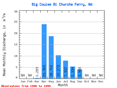
| Statistic | Jan | Feb | Mar | Apr | May | Jun | Jul | Aug | Sep | Oct | Nov | Dec | Annual |
|---|---|---|---|---|---|---|---|---|---|---|---|---|---|
| Mean | 0.29 | 23.96 | 18.70 | 10.27 | 7.92 | 5.33 | 3.99 | ||||||
| Standard Deviation | 0.39 | 2.73 | 6.02 | 3.21 | 1.22 | 3.62 | 5.19 | ||||||
| Min | 0.01 | 22.03 | 14.45 | 8.00 | 7.06 | 2.77 | 0.32 | ||||||
| Max | 0.56 | 25.90 | 22.96 | 12.54 | 8.79 | 7.89 | 7.66 | ||||||
| Coefficient of Variation | 1.34 | 0.11 | 0.32 | 0.31 | 0.15 | 0.68 | 1.30 |
 Return to R-Arctic Net Home Page