|
|
| Point ID: 9538 | Downloads | Plots | Site Data | Code: 05056270 |
|
| Download | |
|---|---|
| Site Descriptor Information | Site Time Series Data |
| Link to all available data | |
|
|
|
| View: | Statistics | All |
| Units: | mm |
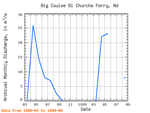
| Year | Jan | Feb | Mar | Apr | May | Jun | Jul | Aug | Sep | Oct | Nov | Dec | Annual | 1998 | 0.56 | 25.90 | 14.45 | 8.00 | 7.06 | 2.77 | 0.32 | 1999 | 0.01 | 22.03 | 22.96 | 12.54 | 8.79 | 7.89 | 7.66 |
|---|
 Return to R-Arctic Net Home Page