|
|
|||||||||||||||||
| Point ID: 9538 | Downloads | Plots | Site Data | Code: 05056270 |
|
|
|||||||||||||||||
| Download | |
|---|---|
| Site Descriptor Information | Site Time Series Data |
| Link to all available data | |
| View: | Time Series | All |
| Units: | m3/s |
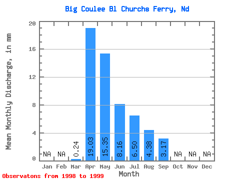
| Statistic | Jan | Feb | Mar | Apr | May | Jun | Jul | Aug | Sep | Oct | Nov | Dec | Annual |
|---|---|---|---|---|---|---|---|---|---|---|---|---|---|
| Mean | 0.24 | 19.04 | 15.35 | 8.16 | 6.50 | 4.38 | 3.17 | ||||||
| Standard Deviation | 0.32 | 2.17 | 4.94 | 2.55 | 1.00 | 2.97 | 4.12 | ||||||
| Min | 0.01 | 17.50 | 11.86 | 6.36 | 5.79 | 2.28 | 0.26 | ||||||
| Max | 0.46 | 20.57 | 18.84 | 9.96 | 7.21 | 6.48 | 6.08 | ||||||
| Coefficient of Variation | 1.34 | 0.11 | 0.32 | 0.31 | 0.15 | 0.68 | 1.30 |
 Return to R-Arctic Net Home Page