|
|
|||||||||||||||||
| Point ID: 9424 | Downloads | Plots | Site Data | Code: 15564450 |
|
|
|||||||||||||||||
| Download | |
|---|---|
| Site Descriptor Information | Site Time Series Data |
| Link to all available data | |
| View: | Time Series | All |
| Units: | mm |
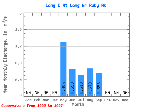
| Statistic | Jan | Feb | Mar | Apr | May | Jun | Jul | Aug | Sep | Oct | Nov | Dec | Annual |
|---|---|---|---|---|---|---|---|---|---|---|---|---|---|
| Mean | 1.30 | 0.66 | 0.51 | 0.67 | 0.56 | ||||||||
| Standard Deviation | 0.78 | 0.31 | 0.26 | 0.09 | 0.05 | ||||||||
| Min | 0.46 | 0.39 | 0.21 | 0.61 | 0.52 | ||||||||
| Max | 2.00 | 0.99 | 0.69 | 0.74 | 0.59 | ||||||||
| Coefficient of Variation | 0.60 | 0.47 | 0.51 | 0.14 | 0.09 |
 Return to R-Arctic Net Home Page