|
|
|||||||||||||||||
| Point ID: 9424 | Downloads | Plots | Site Data | Code: 15564450 |
|
|
|||||||||||||||||
| Download | |
|---|---|
| Site Descriptor Information | Site Time Series Data |
| Link to all available data | |
| View: | Time Series | All |
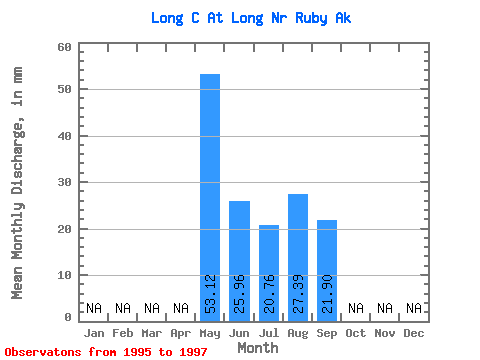
| Units: | m3/s |
| Statistic | Jan | Feb | Mar | Apr | May | Jun | Jul | Aug | Sep | Oct | Nov | Dec | Annual |
|---|---|---|---|---|---|---|---|---|---|---|---|---|---|
| Mean | 53.11 | 25.95 | 20.77 | 27.40 | 21.90 | ||||||||
| Standard Deviation | 31.76 | 12.12 | 10.66 | 3.78 | 2.00 | ||||||||
| Min | 18.72 | 15.35 | 8.55 | 24.73 | 20.49 | ||||||||
| Max | 81.35 | 39.15 | 28.12 | 30.08 | 23.31 | ||||||||
| Coefficient of Variation | 0.60 | 0.47 | 0.51 | 0.14 | 0.09 |
 Return to R-Arctic Net Home Page