|
|
|||||||||||||||||
| Point ID: 891 | Downloads | Plots | Site Data | Other Close Sites | Code: 07FC001 |
|
|
|||||||||||||||||
| Download | |
|---|---|
| Site Descriptor Information | Site Time Series Data |
| Link to all available data | |
| View: | Time Series | All |
| Units: | mm |
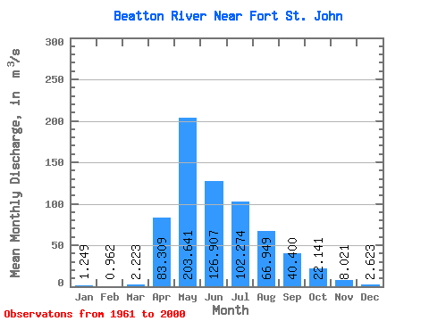
| Statistic | Jan | Feb | Mar | Apr | May | Jun | Jul | Aug | Sep | Oct | Nov | Dec | Annual |
|---|---|---|---|---|---|---|---|---|---|---|---|---|---|
| Mean | 1.25 | 0.96 | 2.22 | 83.31 | 203.64 | 126.91 | 102.27 | 66.95 | 40.40 | 22.14 | 8.02 | 2.62 | 53.68 |
| Standard Deviation | 0.86 | 0.68 | 4.70 | 80.68 | 129.86 | 89.12 | 70.40 | 97.34 | 47.28 | 31.03 | 9.33 | 1.91 | 23.30 |
| Min | 0.20 | 0.10 | 0.27 | 2.57 | 19.70 | 22.80 | 9.36 | 3.34 | 1.61 | 2.92 | 1.84 | 0.27 | 21.64 |
| Max | 3.21 | 2.58 | 28.80 | 345.00 | 519.00 | 407.00 | 332.00 | 418.00 | 213.00 | 192.00 | 53.80 | 9.02 | 136.85 |
| Coefficient of Variation | 0.69 | 0.70 | 2.12 | 0.97 | 0.64 | 0.70 | 0.69 | 1.45 | 1.17 | 1.40 | 1.16 | 0.73 | 0.43 |
| Other Close Sites | ||||||
|---|---|---|---|---|---|---|
| PointID | Latitude | Longitude | Drainage Area | Source | Name | |
| 877 | "PEACE RIVER ABOVE PINE RIVER" | 56.19 | 1897840 | Hydat | ||
| 898 | "PEACE RIVER NEAR TAYLOR" | 56.13 | 1893314 | Hydat | ||
 Return to R-Arctic Net Home Page