|
|
|||||||||||||||||
| Point ID: 898 | Downloads | Plots | Site Data | Other Close Sites | Code: 07FD002 |
|
|
|||||||||||||||||
| Download | |
|---|---|
| Site Descriptor Information | Site Time Series Data |
| Link to all available data | |
| View: | Time Series | All |
| Units: | mm |
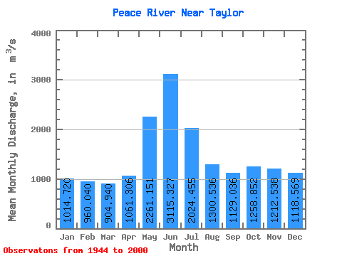
| Statistic | Jan | Feb | Mar | Apr | May | Jun | Jul | Aug | Sep | Oct | Nov | Dec | Annual |
|---|---|---|---|---|---|---|---|---|---|---|---|---|---|
| Mean | 1014.72 | 960.04 | 904.94 | 1061.31 | 2261.15 | 3115.33 | 2024.45 | 1300.54 | 1129.04 | 1258.85 | 1212.54 | 1118.57 | 1431.20 |
| Standard Deviation | 608.55 | 604.45 | 570.76 | 498.49 | 955.12 | 1838.92 | 1099.91 | 641.58 | 334.56 | 329.11 | 458.79 | 603.52 | 275.24 |
| Min | 211.00 | 185.00 | 173.00 | 204.00 | 802.00 | 794.00 | 601.00 | 279.00 | 318.00 | 423.00 | 271.00 | 226.00 | 490.17 |
| Max | 1990.00 | 1870.00 | 1880.00 | 2150.00 | 4840.00 | 8160.00 | 5720.00 | 3590.00 | 1880.00 | 1980.00 | 1950.00 | 1960.00 | 2121.67 |
| Coefficient of Variation | 0.60 | 0.63 | 0.63 | 0.47 | 0.42 | 0.59 | 0.54 | 0.49 | 0.30 | 0.26 | 0.38 | 0.54 | 0.19 |
| Other Close Sites | ||||||
|---|---|---|---|---|---|---|
| PointID | Latitude | Longitude | Drainage Area | Source | Name | |
| 877 | "PEACE RIVER ABOVE PINE RIVER" | 56.19 | 1897840 | Hydat | ||
| 891 | "BEATTON RIVER NEAR FORT ST. JOHN" | 56.27 | 1885716 | Hydat | ||
 Return to R-Arctic Net Home Page