|
|
|||||||||||||||||
| Point ID: 891 | Downloads | Plots | Site Data | Other Close Sites | Code: 07FC001 |
|
|
|||||||||||||||||
| Download | |
|---|---|
| Site Descriptor Information | Site Time Series Data |
| Link to all available data | |
|
|
| View: | Statistics | Time Series |
| Units: | mm |
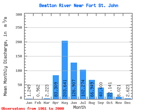
| Statistic | Jan | Feb | Mar | Apr | May | Jun | Jul | Aug | Sep | Oct | Nov | Dec | Annual |
|---|---|---|---|---|---|---|---|---|---|---|---|---|---|
| Mean | 1.25 | 0.96 | 2.22 | 83.31 | 203.64 | 126.91 | 102.27 | 66.95 | 40.40 | 22.14 | 8.02 | 2.62 | 53.68 |
| Standard Deviation | 0.86 | 0.68 | 4.70 | 80.68 | 129.86 | 89.12 | 70.40 | 97.34 | 47.28 | 31.03 | 9.33 | 1.91 | 23.30 |
| Min | 0.20 | 0.10 | 0.27 | 2.57 | 19.70 | 22.80 | 9.36 | 3.34 | 1.61 | 2.92 | 1.84 | 0.27 | 21.64 |
| Max | 3.21 | 2.58 | 28.80 | 345.00 | 519.00 | 407.00 | 332.00 | 418.00 | 213.00 | 192.00 | 53.80 | 9.02 | 136.85 |
| Coefficient of Variation | 0.69 | 0.70 | 2.12 | 0.97 | 0.64 | 0.70 | 0.69 | 1.45 | 1.17 | 1.40 | 1.16 | 0.73 | 0.43 |
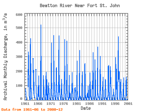
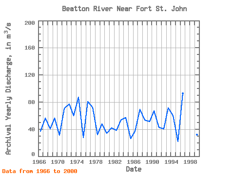
| Year | Jan | Feb | Mar | Apr | May | Jun | Jul | Aug | Sep | Oct | Nov | Dec | Annual | 1961 | 76.30 | 39.60 | 5.54 | 2.72 | 1962 | 146.00 | 91.80 | 332.00 | 286.00 | 58.50 | 32.10 | 20.80 | 5.21 | 1963 | 3.11 | 2.21 | 1.68 | 345.00 | 425.00 | 76.20 | 77.70 | 83.30 | 29.90 | 9.93 | 1964 | 286.00 | 90.50 | 42.90 | 206.00 | 43.60 | 16.80 | 1965 | 209.00 | 114.00 | 84.30 | 5.72 | 12.80 | 7.97 | 1.84 | 0.47 | 1966 | 0.43 | 0.47 | 0.89 | 80.80 | 99.20 | 22.80 | 167.00 | 36.30 | 23.00 | 5.83 | 3.59 | 1.99 | 36.86 | 1967 | 1.35 | 1.03 | 0.95 | 21.40 | 519.00 | 84.20 | 18.50 | 13.10 | 1.61 | 9.01 | 5.77 | 2.28 | 56.52 | 1968 | 0.67 | 0.86 | 1.67 | 31.20 | 168.00 | 114.00 | 67.20 | 47.50 | 23.00 | 19.80 | 8.07 | 1.30 | 40.27 | 1969 | 0.42 | 0.17 | 0.35 | 143.00 | 193.00 | 33.50 | 75.80 | 3.34 | 141.00 | 61.50 | 23.70 | 3.59 | 56.61 | 1970 | 1.05 | 0.59 | 0.55 | 71.20 | 120.00 | 72.70 | 80.20 | 11.30 | 7.06 | 8.07 | 3.12 | 0.27 | 31.34 | 1971 | 0.31 | 0.29 | 0.29 | 36.70 | 116.00 | 395.00 | 205.00 | 31.10 | 32.00 | 19.80 | 7.99 | 3.00 | 70.62 | 1972 | 1.05 | 0.75 | 1.31 | 88.40 | 447.00 | 96.50 | 121.00 | 105.00 | 22.30 | 31.70 | 7.96 | 3.02 | 77.17 | 1973 | 1.84 | 1.48 | 2.46 | 214.00 | 224.00 | 132.00 | 73.20 | 26.40 | 22.20 | 12.10 | 4.57 | 2.60 | 59.74 | 1974 | 1.39 | 1.01 | 1.00 | 246.00 | 444.00 | 51.70 | 172.00 | 40.40 | 30.60 | 30.90 | 15.70 | 6.25 | 86.75 | 1975 | 1.39 | 0.82 | 0.95 | 9.82 | 144.00 | 84.00 | 46.70 | 26.90 | 7.05 | 3.55 | 1.93 | 0.90 | 27.33 | 1976 | 0.54 | 0.50 | 0.60 | 13.60 | 49.50 | 168.00 | 220.00 | 418.00 | 55.60 | 30.00 | 6.65 | 3.32 | 80.53 | 1977 | 2.09 | 2.34 | 2.50 | 82.30 | 192.00 | 407.00 | 84.10 | 36.60 | 23.10 | 21.10 | 7.12 | 2.10 | 71.86 | 1978 | 1.35 | 0.98 | 0.82 | 28.10 | 172.00 | 89.10 | 12.40 | 14.80 | 44.30 | 18.70 | 3.55 | 0.84 | 32.25 | 1979 | 0.27 | 0.12 | 0.46 | 2.57 | 111.00 | 115.00 | 191.00 | 46.30 | 77.80 | 19.50 | 4.31 | 0.73 | 47.42 | 1980 | 0.32 | 0.23 | 0.57 | 6.43 | 19.70 | 81.00 | 82.20 | 61.50 | 86.50 | 49.90 | 17.80 | 3.04 | 34.10 | 1981 | 0.74 | 0.36 | 0.27 | 75.00 | 270.00 | 86.30 | 32.60 | 16.50 | 11.00 | 5.51 | 4.46 | 1.45 | 42.02 | 1982 | 0.57 | 0.70 | 0.71 | 26.50 | 343.00 | 32.30 | 9.36 | 27.30 | 11.40 | 6.80 | 3.88 | 1.61 | 38.68 | 1983 | 0.43 | 0.32 | 0.55 | 85.40 | 147.00 | 194.00 | 169.00 | 24.10 | 8.51 | 6.34 | 3.34 | 0.96 | 53.33 | 1984 | 0.40 | 0.51 | 0.76 | 15.70 | 241.00 | 253.00 | 109.00 | 14.50 | 31.90 | 10.90 | 3.08 | 1.59 | 56.86 | 1985 | 0.95 | 0.67 | 0.68 | 32.60 | 45.40 | 48.00 | 25.40 | 13.00 | 95.60 | 39.10 | 8.50 | 2.47 | 26.03 | 1986 | 1.28 | 1.12 | 2.06 | 25.10 | 189.00 | 27.40 | 125.00 | 25.00 | 12.70 | 26.20 | 4.86 | 3.17 | 36.91 | 1987 | 1.63 | 1.26 | 1.62 | 83.30 | 122.00 | 143.00 | 75.70 | 327.00 | 51.00 | 10.90 | 6.12 | 2.73 | 68.86 | 1988 | 1.42 | 1.65 | 4.84 | 46.00 | 279.00 | 125.00 | 139.00 | 22.00 | 8.50 | 5.14 | 3.86 | 3.63 | 53.34 | 1989 | 0.80 | 0.60 | 0.70 | 73.20 | 367.00 | 60.10 | 30.90 | 28.00 | 15.40 | 24.70 | 10.70 | 6.46 | 51.55 | 1990 | 2.73 | 0.92 | 3.61 | 120.00 | 303.00 | 288.00 | 67.00 | 9.62 | 3.12 | 2.92 | 2.01 | 1.49 | 67.03 | 1991 | 1.41 | 0.87 | 2.16 | 79.80 | 100.00 | 159.00 | 113.00 | 20.00 | 16.60 | 7.23 | 4.94 | 2.80 | 42.32 | 1992 | 2.39 | 2.58 | 28.80 | 117.00 | 142.00 | 130.00 | 24.10 | 8.14 | 13.10 | 14.60 | 3.07 | 0.73 | 40.54 | 1993 | 0.20 | 0.27 | 0.92 | 29.50 | 29.20 | 234.00 | 198.00 | 239.00 | 83.30 | 23.10 | 10.30 | 5.70 | 71.12 | 1994 | 2.52 | 1.89 | 4.70 | 232.00 | 178.00 | 112.00 | 155.00 | 22.10 | 4.40 | 3.62 | 2.32 | 0.86 | 59.95 | 1995 | 0.40 | 0.10 | 0.65 | 32.40 | 34.80 | 37.50 | 77.40 | 28.70 | 31.10 | 10.40 | 3.67 | 2.50 | 21.64 | 1996 | 1.61 | 1.28 | 1.51 | 77.00 | 294.00 | 199.00 | 195.00 | 74.20 | 213.00 | 38.40 | 11.00 | 4.39 | 92.53 | 1997 | 2.84 | 2.33 | 2.20 | 245.00 | 438.00 | 184.00 | 144.00 | 198.00 | 171.00 | 192.00 | 53.80 | 9.02 | 136.85 | 1998 | 3.21 | 1.79 | 3.54 | 104.00 | 142.00 | 58.40 | 55.90 | 22.00 | 2.79 | 6.81 | 4.14 | 1.28 | 33.82 | 1999 | 0.90 | 0.86 | 1.14 | 69.00 | 81.20 | 153.00 | 38.80 | 22.10 | 7.26 | 3.98 | 2.30 | 1.65 | 31.85 | 2000 | 0.97 | 0.72 | 1.54 | 10.10 | 112.00 | 157.00 | 114.00 | 31.60 | 79.70 | 16.60 | 5.96 | 1.64 | 44.32 |
|---|
| Other Close Sites | ||||||
|---|---|---|---|---|---|---|
| PointID | Latitude | Longitude | Drainage Area | Source | Name | |
| 877 | "PEACE RIVER ABOVE PINE RIVER" | 56.19 | 1897840 | Hydat | ||
| 898 | "PEACE RIVER NEAR TAYLOR" | 56.13 | 1893314 | Hydat | ||
 Return to R-Arctic Net Home Page