|
|
|||||||||||||||||
| Point ID: 866 | Downloads | Plots | Site Data | Other Close Sites | Code: 07EE002 |
|
|
|||||||||||||||||
| Download | |
|---|---|
| Site Descriptor Information | Site Time Series Data |
| Link to all available data | |
| View: | Time Series | All |
| Units: | mm |
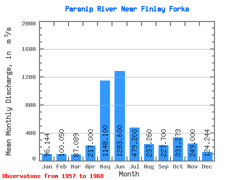
| Statistic | Jan | Feb | Mar | Apr | May | Jun | Jul | Aug | Sep | Oct | Nov | Dec | Annual |
|---|---|---|---|---|---|---|---|---|---|---|---|---|---|
| Mean | 96.14 | 100.05 | 87.09 | 217.00 | 1148.10 | 1283.60 | 479.20 | 237.26 | 227.70 | 331.27 | 249.00 | 124.24 | 389.52 |
| Standard Deviation | 17.17 | 21.05 | 18.03 | 92.81 | 194.44 | 434.25 | 182.20 | 146.69 | 80.74 | 75.42 | 82.80 | 39.99 | 64.74 |
| Min | 70.80 | 68.30 | 62.70 | 118.00 | 777.00 | 788.00 | 204.00 | 92.00 | 104.00 | 168.00 | 128.00 | 80.30 | 339.18 |
| Max | 117.00 | 132.00 | 108.00 | 392.00 | 1390.00 | 2240.00 | 846.00 | 591.00 | 362.00 | 463.00 | 435.00 | 206.00 | 516.24 |
| Coefficient of Variation | 0.18 | 0.21 | 0.21 | 0.43 | 0.17 | 0.34 | 0.38 | 0.62 | 0.35 | 0.23 | 0.33 | 0.32 | 0.17 |
| Other Close Sites | ||||||
|---|---|---|---|---|---|---|
| PointID | Latitude | Longitude | Drainage Area | Source | Name | |
| 858 | "FINLAY RIVER AT FINLAY FORKS" | 56.03 | 2076119 | Hydat | ||
 Return to R-Arctic Net Home Page