|
|
|||||||||||||||||
| Point ID: 858 | Downloads | Plots | Site Data | Other Close Sites | Code: 07EB001 |
|
|
|||||||||||||||||
| Download | |
|---|---|
| Site Descriptor Information | Site Time Series Data |
| Link to all available data | |
| View: | Time Series | All |
| Units: | mm |
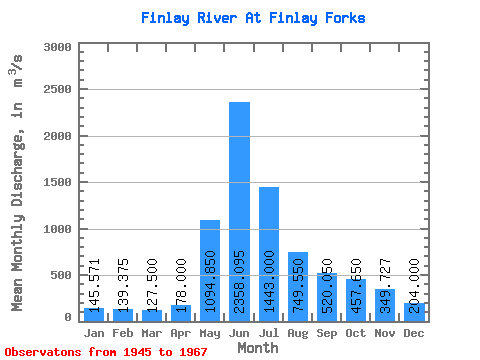
| Statistic | Jan | Feb | Mar | Apr | May | Jun | Jul | Aug | Sep | Oct | Nov | Dec | Annual |
|---|---|---|---|---|---|---|---|---|---|---|---|---|---|
| Mean | 145.57 | 139.38 | 127.50 | 178.00 | 1094.85 | 2358.09 | 1443.00 | 749.55 | 520.05 | 457.65 | 349.73 | 204.00 | 678.64 |
| Standard Deviation | 17.02 | 24.02 | 17.19 | 64.98 | 429.40 | 526.54 | 403.70 | 221.25 | 127.55 | 109.79 | 78.74 | 62.77 | 32.03 |
| Min | 115.00 | 114.00 | 101.00 | 124.00 | 292.00 | 1850.00 | 758.00 | 399.00 | 310.00 | 267.00 | 203.00 | 132.00 | 643.08 |
| Max | 169.00 | 187.00 | 157.00 | 316.00 | 1830.00 | 4010.00 | 2010.00 | 1220.00 | 762.00 | 622.00 | 449.00 | 299.00 | 705.25 |
| Coefficient of Variation | 0.12 | 0.17 | 0.14 | 0.36 | 0.39 | 0.22 | 0.28 | 0.29 | 0.24 | 0.24 | 0.23 | 0.31 | 0.05 |
| Other Close Sites | ||||||
|---|---|---|---|---|---|---|
| PointID | Latitude | Longitude | Drainage Area | Source | Name | |
| 866 | "PARSNIP RIVER NEAR FINLAY FORKS" | 55.84 | 2079789 | Hydat | ||
 Return to R-Arctic Net Home Page