|
|
|||||||||||||||||
| Point ID: 858 | Downloads | Plots | Site Data | Other Close Sites | Code: 07EB001 |
|
|
|||||||||||||||||
| Download | |
|---|---|
| Site Descriptor Information | Site Time Series Data |
| Link to all available data | |
| View: | Time Series | All |
| Units: | m3/s |
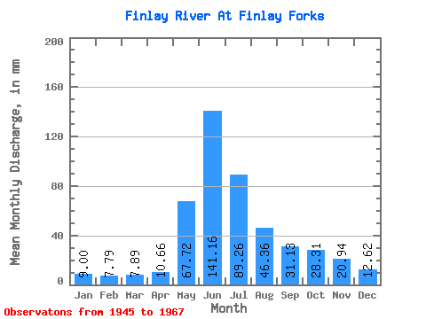
| Statistic | Jan | Feb | Mar | Apr | May | Jun | Jul | Aug | Sep | Oct | Nov | Dec | Annual |
|---|---|---|---|---|---|---|---|---|---|---|---|---|---|
| Mean | 9.00 | 7.85 | 7.89 | 10.65 | 67.71 | 141.16 | 89.25 | 46.36 | 31.13 | 28.30 | 20.93 | 12.62 | 494.64 |
| Standard Deviation | 1.05 | 1.35 | 1.06 | 3.89 | 26.56 | 31.52 | 24.97 | 13.68 | 7.63 | 6.79 | 4.71 | 3.88 | 23.35 |
| Min | 7.11 | 6.42 | 6.25 | 7.42 | 18.06 | 110.74 | 46.88 | 24.68 | 18.56 | 16.51 | 12.15 | 8.16 | 468.72 |
| Max | 10.45 | 10.54 | 9.71 | 18.92 | 113.18 | 240.04 | 124.31 | 75.45 | 45.61 | 38.47 | 26.88 | 18.49 | 514.03 |
| Coefficient of Variation | 0.12 | 0.17 | 0.14 | 0.36 | 0.39 | 0.22 | 0.28 | 0.29 | 0.24 | 0.24 | 0.23 | 0.31 | 0.05 |
| Other Close Sites | ||||||
|---|---|---|---|---|---|---|
| PointID | Latitude | Longitude | Drainage Area | Source | Name | |
| 866 | "PARSNIP RIVER NEAR FINLAY FORKS" | 55.84 | 2079789 | Hydat | ||
 Return to R-Arctic Net Home Page