|
|
|||||||||||||||||
| Point ID: 866 | Downloads | Plots | Site Data | Other Close Sites | Code: 07EE002 |
|
|
|||||||||||||||||
| Download | |
|---|---|
| Site Descriptor Information | Site Time Series Data |
| Link to all available data | |
| View: | Time Series | All |
| Units: | m3/s |
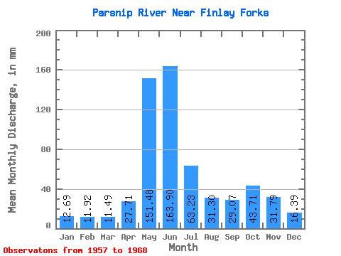
| Statistic | Jan | Feb | Mar | Apr | May | Jun | Jul | Aug | Sep | Oct | Nov | Dec | Annual |
|---|---|---|---|---|---|---|---|---|---|---|---|---|---|
| Mean | 12.68 | 12.03 | 11.49 | 27.71 | 151.46 | 163.90 | 63.22 | 31.30 | 29.07 | 43.70 | 31.79 | 16.39 | 605.58 |
| Standard Deviation | 2.27 | 2.53 | 2.38 | 11.85 | 25.65 | 55.45 | 24.04 | 19.35 | 10.31 | 9.95 | 10.57 | 5.28 | 100.65 |
| Min | 9.34 | 8.21 | 8.27 | 15.07 | 102.50 | 100.62 | 26.91 | 12.14 | 13.28 | 22.16 | 16.34 | 10.59 | 527.31 |
| Max | 15.44 | 15.87 | 14.25 | 50.05 | 183.37 | 286.01 | 111.61 | 77.97 | 46.22 | 61.08 | 55.54 | 27.18 | 802.59 |
| Coefficient of Variation | 0.18 | 0.21 | 0.21 | 0.43 | 0.17 | 0.34 | 0.38 | 0.62 | 0.35 | 0.23 | 0.33 | 0.32 | 0.17 |
| Other Close Sites | ||||||
|---|---|---|---|---|---|---|
| PointID | Latitude | Longitude | Drainage Area | Source | Name | |
| 858 | "FINLAY RIVER AT FINLAY FORKS" | 56.03 | 2076119 | Hydat | ||
 Return to R-Arctic Net Home Page