|
|
|||||||||||||||||
| Point ID: 862 | Downloads | Plots | Site Data | Code: 07EC003 |
|
|
|||||||||||||||||
| Download | |
|---|---|
| Site Descriptor Information | Site Time Series Data |
| Link to all available data | |
| View: | Time Series | All |
| Units: | mm |
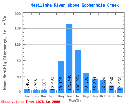
| Statistic | Jan | Feb | Mar | Apr | May | Jun | Jul | Aug | Sep | Oct | Nov | Dec | Annual |
|---|---|---|---|---|---|---|---|---|---|---|---|---|---|
| Mean | 9.40 | 7.71 | 7.37 | 10.49 | 79.13 | 171.44 | 106.22 | 49.80 | 35.80 | 32.56 | 18.46 | 12.96 | 45.11 |
| Standard Deviation | 1.55 | 1.05 | 0.94 | 3.07 | 33.67 | 38.75 | 32.03 | 14.52 | 8.90 | 9.54 | 3.80 | 3.04 | 5.71 |
| Min | 7.14 | 6.19 | 5.74 | 5.12 | 36.20 | 115.00 | 51.80 | 29.90 | 23.00 | 14.50 | 11.50 | 7.07 | 35.42 |
| Max | 12.40 | 9.66 | 9.23 | 21.40 | 162.00 | 264.00 | 184.00 | 91.00 | 55.10 | 49.90 | 25.50 | 20.40 | 56.10 |
| Coefficient of Variation | 0.16 | 0.14 | 0.13 | 0.29 | 0.43 | 0.23 | 0.30 | 0.29 | 0.25 | 0.29 | 0.21 | 0.23 | 0.13 |
 Return to R-Arctic Net Home Page