|
|
|||||||||||||||||
| Point ID: 862 | Downloads | Plots | Site Data | Code: 07EC003 |
|
|
|||||||||||||||||
| Download | |
|---|---|
| Site Descriptor Information | Site Time Series Data |
| Link to all available data | |
| View: | Time Series | All |
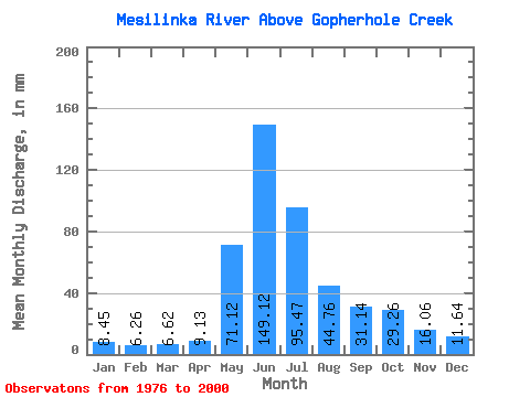
| Units: | m3/s |
| Statistic | Jan | Feb | Mar | Apr | May | Jun | Jul | Aug | Sep | Oct | Nov | Dec | Annual |
|---|---|---|---|---|---|---|---|---|---|---|---|---|---|
| Mean | 8.45 | 6.31 | 6.62 | 9.13 | 71.11 | 149.12 | 95.46 | 44.75 | 31.14 | 29.26 | 16.06 | 11.64 | 477.75 |
| Standard Deviation | 1.39 | 0.86 | 0.85 | 2.67 | 30.26 | 33.70 | 28.79 | 13.04 | 7.74 | 8.58 | 3.31 | 2.73 | 60.47 |
| Min | 6.42 | 5.07 | 5.16 | 4.45 | 32.53 | 100.03 | 46.55 | 26.87 | 20.00 | 13.03 | 10.00 | 6.35 | 375.16 |
| Max | 11.14 | 7.91 | 8.29 | 18.61 | 145.58 | 229.63 | 165.35 | 81.78 | 47.93 | 44.84 | 22.18 | 18.33 | 594.15 |
| Coefficient of Variation | 0.16 | 0.14 | 0.13 | 0.29 | 0.43 | 0.23 | 0.30 | 0.29 | 0.25 | 0.29 | 0.21 | 0.23 | 0.13 |
 Return to R-Arctic Net Home Page