|
|
| Point ID: 862 | Downloads | Plots | Site Data | Code: 07EC003 |
|
| Download | |
|---|---|
| Site Descriptor Information | Site Time Series Data |
| Link to all available data | |
|
|
|
| View: | Statistics | All |
| Units: | mm |
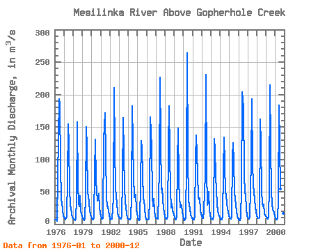
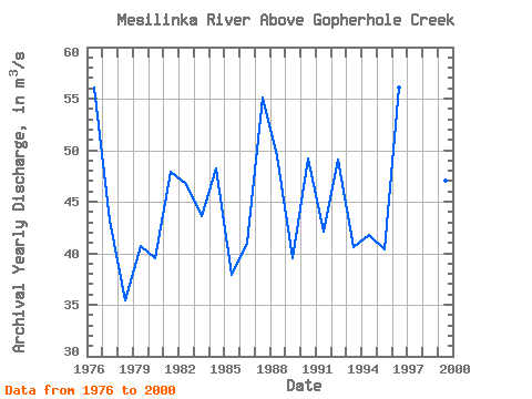
| Year | Jan | Feb | Mar | Apr | May | Jun | Jul | Aug | Sep | Oct | Nov | Dec | Annual | 1976 | 7.39 | 7.00 | 6.65 | 5.12 | 72.90 | 193.00 | 184.00 | 91.00 | 37.10 | 33.90 | 21.20 | 13.40 | 56.05 | 1977 | 9.82 | 8.67 | 7.31 | 12.40 | 70.20 | 154.00 | 122.00 | 56.00 | 27.60 | 25.10 | 14.60 | 10.70 | 43.20 | 1978 | 8.84 | 7.21 | 6.32 | 8.52 | 39.40 | 158.00 | 60.70 | 32.50 | 27.90 | 43.40 | 20.50 | 11.80 | 35.42 | 1979 | 8.97 | 6.68 | 6.31 | 7.66 | 42.30 | 150.00 | 119.00 | 46.40 | 46.00 | 30.30 | 13.60 | 11.10 | 40.69 | 1980 | 8.89 | 6.83 | 6.68 | 8.91 | 81.80 | 131.00 | 67.40 | 36.40 | 38.10 | 46.60 | 24.80 | 16.40 | 39.48 | 1981 | 12.00 | 8.56 | 8.08 | 9.30 | 131.00 | 171.00 | 106.00 | 41.70 | 27.80 | 27.00 | 18.60 | 14.00 | 47.92 | 1982 | 8.29 | 6.96 | 7.92 | 8.20 | 39.90 | 210.00 | 118.00 | 56.50 | 41.90 | 33.20 | 18.20 | 12.10 | 46.76 | 1983 | 10.40 | 8.70 | 8.28 | 12.60 | 68.10 | 164.00 | 111.00 | 54.20 | 35.20 | 25.10 | 16.40 | 9.58 | 43.63 | 1984 | 7.58 | 6.61 | 7.41 | 10.20 | 40.60 | 182.00 | 126.00 | 73.40 | 41.50 | 45.80 | 21.80 | 16.40 | 48.27 | 1985 | 10.60 | 7.23 | 6.17 | 7.06 | 60.70 | 128.00 | 116.00 | 38.30 | 37.60 | 24.60 | 12.10 | 7.07 | 37.95 | 1986 | 7.39 | 6.70 | 6.68 | 8.03 | 36.20 | 165.00 | 119.00 | 43.80 | 27.50 | 39.70 | 19.70 | 12.50 | 41.02 | 1987 | 9.05 | 8.76 | 8.76 | 7.95 | 81.40 | 226.00 | 130.00 | 53.10 | 55.10 | 39.40 | 23.10 | 18.90 | 55.13 | 1988 | 10.40 | 7.69 | 7.62 | 13.20 | 119.00 | 182.00 | 110.00 | 51.40 | 25.40 | 31.70 | 20.80 | 14.00 | 49.43 | 1989 | 10.80 | 7.20 | 6.49 | 12.30 | 94.90 | 148.00 | 65.90 | 41.90 | 26.20 | 29.10 | 17.50 | 13.30 | 39.47 | 1990 | 8.29 | 6.44 | 7.08 | 10.40 | 95.30 | 264.00 | 105.00 | 36.00 | 23.00 | 14.50 | 11.50 | 9.08 | 49.22 | 1991 | 7.14 | 7.52 | 6.76 | 12.80 | 102.00 | 137.00 | 79.20 | 39.80 | 37.70 | 39.80 | 20.50 | 15.20 | 42.12 | 1992 | 11.00 | 8.82 | 9.23 | 21.40 | 77.50 | 231.00 | 83.70 | 29.90 | 31.50 | 49.90 | 21.50 | 14.20 | 49.14 | 1993 | 9.16 | 8.11 | 7.26 | 12.70 | 132.00 | 115.00 | 73.70 | 53.40 | 30.30 | 19.90 | 15.80 | 10.10 | 40.62 | 1994 | 7.97 | 6.68 | 7.19 | 11.10 | 83.20 | 134.00 | 93.20 | 47.80 | 47.30 | 30.20 | 18.70 | 13.60 | 41.74 | 1995 | 10.70 | 9.47 | 8.21 | 10.60 | 104.00 | 125.00 | 95.90 | 49.30 | 30.10 | 19.10 | 12.50 | 9.26 | 40.34 | 1996 | 7.39 | 6.19 | 5.74 | 11.20 | 53.40 | 204.00 | 180.00 | 77.00 | 47.40 | 45.80 | 21.70 | 13.40 | 56.10 | 1997 | 10.40 | 8.81 | 8.36 | 10.80 | 96.30 | 193.00 | 95.10 | 59.50 | 48.40 | 39.00 | 25.50 | 20.40 | 51.30 | 1998 | 12.40 | 9.66 | 9.00 | 10.00 | 162.00 | 124.00 | 51.80 | 31.40 | 27.50 | 30.70 | 16.60 | 13.80 | 41.57 | 1999 | 11.50 | 9.13 | 8.00 | 11.00 | 56.80 | 214.00 | 122.00 | 49.60 | 30.60 | 22.40 | 17.30 | 11.60 | 46.99 | 2000 | 8.76 | 7.02 | 6.66 | 8.84 | 37.30 | 183.00 | 121.00 | 54.60 | 46.40 | 27.70 | 17.00 | 12.00 | 44.19 |
|---|
 Return to R-Arctic Net Home Page