|
|
|||||||||||||||||
| Point ID: 7752 | Downloads | Plots | Site Data | Code: 05DE911 |
|
|
|||||||||||||||||
| Download | |
|---|---|
| Site Descriptor Information | Site Time Series Data |
| Link to all available data | |
| View: | Time Series | All |
| Units: | mm |
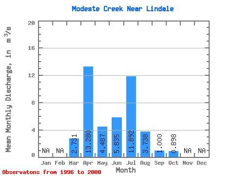
| Statistic | Jan | Feb | Mar | Apr | May | Jun | Jul | Aug | Sep | Oct | Nov | Dec | Annual |
|---|---|---|---|---|---|---|---|---|---|---|---|---|---|
| Mean | 2.73 | 13.28 | 4.49 | 5.83 | 11.89 | 3.74 | 1.00 | 0.90 | |||||
| Standard Deviation | 2.38 | 11.85 | 2.98 | 5.82 | 9.11 | 2.61 | 0.51 | 0.74 | |||||
| Min | 1.00 | 1.13 | 0.41 | 1.02 | 2.79 | 1.52 | 0.37 | 0.31 | |||||
| Max | 6.85 | 29.80 | 8.75 | 13.40 | 24.30 | 8.15 | 1.77 | 2.16 | |||||
| Coefficient of Variation | 0.87 | 0.89 | 0.66 | 1.00 | 0.77 | 0.70 | 0.51 | 0.82 |
 Return to R-Arctic Net Home Page