|
|
|||||||||||||||||
| Point ID: 7752 | Downloads | Plots | Site Data | Code: 05DE911 |
|
|
|||||||||||||||||
| Download | |
|---|---|
| Site Descriptor Information | Site Time Series Data |
| Link to all available data | |
| View: | Time Series | All |
| Units: | m3/s |
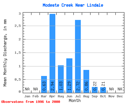
| Statistic | Jan | Feb | Mar | Apr | May | Jun | Jul | Aug | Sep | Oct | Nov | Dec | Annual |
|---|---|---|---|---|---|---|---|---|---|---|---|---|---|
| Mean | 0.62 | 2.94 | 1.03 | 1.29 | 2.72 | 0.86 | 0.22 | 0.21 | |||||
| Standard Deviation | 0.54 | 2.62 | 0.68 | 1.29 | 2.08 | 0.60 | 0.11 | 0.17 | |||||
| Min | 0.23 | 0.25 | 0.09 | 0.23 | 0.64 | 0.35 | 0.08 | 0.07 | |||||
| Max | 1.57 | 6.60 | 2.00 | 2.97 | 5.56 | 1.86 | 0.39 | 0.49 | |||||
| Coefficient of Variation | 0.87 | 0.89 | 0.66 | 1.00 | 0.77 | 0.70 | 0.51 | 0.82 |
 Return to R-Arctic Net Home Page