|
|
| Point ID: 7752 | Downloads | Plots | Site Data | Code: 05DE911 |
|
| Download | |
|---|---|
| Site Descriptor Information | Site Time Series Data |
| Link to all available data | |
|
|
|
| View: | Statistics | All |
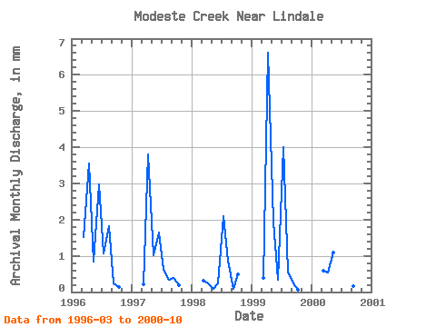
| Units: | m3/s |
| Year | Jan | Feb | Mar | Apr | May | Jun | Jul | Aug | Sep | Oct | Nov | Dec | Annual | 1996 | 1.57 | 3.54 | 0.88 | 2.97 | 1.09 | 1.86 | 0.23 | 0.15 | 1997 | 0.23 | 3.79 | 1.05 | 1.64 | 0.64 | 0.35 | 0.39 | 0.21 | 1998 | 0.33 | 0.25 | 0.09 | 0.23 | 2.17 | 0.89 | 0.08 | 0.49 | 1999 | 0.40 | 6.60 | 2.00 | 0.34 | 4.14 | 0.58 | 0.23 | 0.07 | 2000 | 0.59 | 0.53 | 1.12 | 5.56 | 0.59 | 0.17 | 0.11 |
|---|
 Return to R-Arctic Net Home Page